|
|
Post by herosrest on Nov 3, 2023 16:47:33 GMT -6
As mentioned from time to time, time is considered to be linear and yet the very infs which constructed its empiracal corset have but to blink, to step back (or forward) into the dream that is time. It is a pillar of advanced and modern life and the living of it which is omnipotent. Time is.....  ? 🤗 So, step back. Back a mere few..... minutes into Reno creek that has had a number of names each lasting as long perhaps as the ash which once flowered and grew. Battalions of hardy cavalry pound along trails flanking the meandering stream and by God does it wander aimlessly in curls and loops across and down that valley. They are. There are your Indians and running like the devil. We know of them through the first Cheyenne account given Indian Agent Miles at Darlington but few weeks after military catastrophe. We know from participants such as Hare that the band of fifty or more existed. We know it from Kanipe. It is interesting that Custer's scouts knew not of them but the question is did they go high or low. Left or right. Bluffs or the valley? Did they actually exist? Are they a hunting party of recent myth? Can this dirigible be deflated? That is truly difficult in pedantic terms, for how can something not there, be dismissed..... Varic discourse perhaps. Were a bunch of hostiles fleeing ahead of 7th Cavalry yes. |
|
|
|
Post by johnson1941 on Nov 4, 2023 0:56:45 GMT -6
George W. Wylie Junction City October 16, 1910 Men dismounted and put horses behind Edgerly peaks and behind hill to east and men formed line over this hill from east to west......Weir did so and changed his mind about leaving the place. Accordingly the men were dismounted and the horses led behind the hill. Edgerly We moved along on that bluff for a short distance, when the Indians commenced to fire on us. The troops were all dismounted, formed on the top of the ridge and returned the fireCamp, Edgerly/Weir Peaks aka Weir Point See if two peaks and a narrow flat-top crescent shaped hill adjacent thereto on the east will answer to description at Weir peaks. Yes.
The crescent is 350 ft long around the crescent. Crescent is concave toward the west.
************************************************ Odometer used on hub of wheel July 31, 1911. Vincent Charley Coulee 5190.Sharpshooter Hill 5437. Retreat point 5460. K Co. line 5600. Benteen intrenchment 5656. South end of Benteen line 5700. Ford A 6377. Bearings July 28. N End of Benteen's line to Sharpshooters hill N 45 W. To Edgerly Peak N 58 W. To Weir's hill N 68 WTo DeWolf marker N 64 WSharpshooters hill is 1280 feet long and the course is N 44 W. It holds its height pretty much this whole length. It consists of four bumps a little higher than the average height of hill. The second bump from the south is 100 feet from the first and the other two about 500 feet apart.From Weir Hill one can see the custodian's house but not the battlefield.
From point under Sharpshooter Hill Custer could not see even this much of the camp and this is probably the last point from which he looked before starting down south coulee.Godfrey When we got to the ridge in front of Reno's position I observed some Indians making all haste to get possession of a hill to the right....The Indians now took possession of all the surrounding high points, and opened a heavy fire.Donahue "the first time the name Sharpshooter Ridge {Hill?} appears was on a map drawn by Walter Camp."
John Ryan There was a high ridge on the right and an opening on the right of our lines, and one Indian in particular I must give credit for being a good shot.
While we were lying in this line he fired a shot and killed the fourth man on my right. Soon afterward he fired again and shot the third man. His third shot wounded the man on my right, who jumped back from the line, and down among the rest of the wounded. I thought my turn was coming next. I jumped up, with Captain French, and some half a dozen members of my company, and, instead of firing straight to the front, as we had been doing up to the time of this incident, we wheeled to our right and put in a deadly volley, and I think we put an end to that Indian, as there were no more men killed at that particular spot.
 Godfrey and Camp on (Martin's) ridge with Weir’s HILL behind…  |
|
|
|
Post by johnson1941 on Nov 4, 2023 21:51:48 GMT -6
As seen elsewhere…the ridge Custer command crossed before going down south coulee…often referred to as Martin’s Ridge. It connects the highest point Weir’s Hill with SSH. Did the whole column go on to the ridge to look down?
A. No, sir. The whole column passed over it. Which is the same ridge edgerly passed over, as he followed Custer’s trail, (and can be seen above re: Godfrey/Camp /\) We moved out along the ridge, the highest point, that point “7,” and then we moved down the valley in the general direction of the point “8.” |
|
|
|
Post by johnson1941 on Nov 4, 2023 22:39:48 GMT -6
Now, some may question Sharpshooter’s Hill vs Weir’s Hill…the choice is clearer in 1876 when 1st moving down the bluffs…Weir’s HILL is on the bluffs and is the highest point. Sharpshooter’s Ridge is away from the bluffs. They are as we know connected by Martin’s ridge. If you wanted to see the village, or part of it atleast, go to the bluffs and use the highest point Weir’s Hill like Custer did. Custer first halted on Weir‘s hill and took a look at village…If you wanted to scout for Custer like Reno and Benteen failed to do for a looong time, you would choose SSH, less then 1/2 mile away, cause Edgerly Peaks blocks some of the down-river view from Weir’s Hill. Q.That circular mark is to indicate the position Major Reno took. How far from there can you see the country towards “B”?
A. To that highest point, Weir’s Hill, probably half a mile downReno We had heard firing in that direction and knew it could only be Custer.
I moved to the summit of the highest bluff, but seeing and hearing nothing sent Captain Weir with his company to open communication with himWeir’s Hill " From this hill, can only see the Hunkpapa & Black feet lodges”
"from Weir Hill can see the Custodians house but not the monument nor any part of Custer battlefield"Sharpshooter’s Hill, “the high ground 1/2 mile distant”.. ' the fence around the monument is easily made out...'
'fence posts around the cemetery on Custer Hill are easily made out'If you wanted to watch & direct your troop moving down south coulee, you would choose Capt. Weir’s Hill, like Capt. Weir did…  View compared to SSH…  Eventually Edgerly / Weir et. al. advanced to Edgerly / Weir Peaks to see the Custer Battlefield. |
|
|
|
Post by herosrest on Nov 5, 2023 4:06:18 GMT -6
Hi J You are finding that you can relate Camp's research to terrain and are gaining, or extending your understanding of 'geographics®®'  . Camp did as you and many have and are which is try to rationalise disparate oral and written accounts of events, to the terrain. So........... what did and has this resolved? Nothing, because the history is not about what happened. Did the five companies with Custer go down Cedar Coulee, or ride around the hill and cross the ridge and go middle and/or south to Medicine Tail.... You can draw concrete solid set in molten metal evidence that they either and still have it being argued over in a centuries time. WMC researched it and many, many, many, since and yet the considerable balance of people who have taken an interest know the command went down Cedar Coulee. What should be done? This is just the tip of an iceberg, by the way since arguments over locations for the valley fight, Ford D, and location of the annual reunions can erupt at any moment, and lets not even blink at events on Greasy Grass ridge or the one where Blummer found evidence of fighting which started a long lasting hunt over the hills on the ridges to the east and north of Maguire's 'B', which may or may not have been a crossing place in 1876, if you can figure out where it was and if there was one of them, two, or several. What have 'we', in the sense of the discussions, shown and arrived at? I suspect that you tend towards the southern coulee route for Custer's command. My own discretion is middle since its right flank offers a reasonable route into MTC. What do you think? |
|
|
|
Post by herosrest on Nov 5, 2023 4:26:12 GMT -6
Now, a discussion and clarification of 'your'Weir Hill. it is upriver of my Horizon Ridge and offers no view (none) to the north and west over the ridge or through the gap in the dip to the high hill which terminates the ridge and is known as Weir Point.
If Martin was on the ground at LBH, with WMC, then we can call you Weir Hill, Martin's Weir Hill. Otherwise this is just Camp's supposition which you currently endorse and enthuse. The only troops who rode across SSR were the five companies - maybe. To see the Indian forces on Custer's Battlefield or anywhere downriver of Horizon Ridge, the observations had to be taken from Horizon ridge or beyond it downriver. Nothing, full stop, of the events ala Custer and the five companies east of the river on its right bank, was seen from your Weir Hill, supposed by WMC to be Martin;s Weir Hill. It all rests on WMC and pretty much every conclusion about events which he drew from research as we understand it - is plain flat simple gobbledeegook, rubbish.
|
|
|
|
Post by johnson1941 on Nov 5, 2023 4:32:51 GMT -6
As seen elsewhere…the ridge Custer command crossed before going down south coulee…often referred to as Martin’s Ridge. It connects the highest point Weir’s Hill with SSH.Did the whole column go on to the ridge to look down?
A. No, sir. The whole column passed over it.
Which is the same ridge edgerly passed over, as he followed Custer’s trail, (and can be seen above inthe NPS pic and re: Godfrey/Camp /\) weir HILL is past the horse.  We moved out along the ridge, the highest point, that point “7,” and then we moved down the valley in the general direction of the point “8.” We moved out along the ridge, the highest point, that point “7,” and then we moved down the valley in the general direction of the point “8.”
Inq Martin… Did Custer follow the bottom South Coulee all the way and make turn into Medicine Tail or cut across the hill and save some of the distance. He Dog seemed to think Custer cut across the hill.
No - Custer followed coulee all the way" |
|
|
|
Post by johnson1941 on Nov 5, 2023 4:33:23 GMT -6
Now, some may question Sharpshooter’s Hill vs Weir’s Hill…the choice is clearer in 1876 when 1st moving down the bluffs…Weir’s HILL is on the bluffs and is the highest point. Sharpshooter’s Ridge is away from the bluffs. They are as we know connected by Martin’s ridge. If you wanted to see the village, or part of it atleast, go to the bluffs and use the highest point Weir’s Hill like Custer did.
Custer first halted on Weir‘s hill and took a look at village…
If you wanted to scout for Custer like Reno and Benteen failed to do for a looong time, you would choose SSH, less then 1/2 mile away, cause Edgerly Peaks blocks some of the down-river view from Weir’s Hill.Q.That circular mark is to indicate the position Major Reno took. How far from there can you see the country towards “B”?
A. To that highest point, Weir’s Hill, probably half a mile downReno We had heard firing in that direction and knew it could only be Custer.
I moved to the summit of the highest bluff, but seeing and hearing nothing sent Captain Weir with his company to open communication with him Weir’s Hill " From this hill, can only see the Hunkpapa & Black feet lodges”
"from Weir Hill can see the Custodians house but not the monument nor any part of Custer battlefield"Sharpshooter’s Hill, “the high ground 1/2 mile distant”.. ' the fence around the monument is easily made out...'
'fence posts around the cemetery on Custer Hill are easily made out'Eventually Edgerly / Weir et. al. advanced to Edgerly / Weir Peaks to see the Custer Battlefield. |
|
|
|
Post by herosrest on Nov 5, 2023 4:44:44 GMT -6
 You are looking at Your 'Weir's Hill'. The highest point. This is because the entire research by WMC is complete flumax (Feline respiratory pump). |
|
|
|
Post by johnson1941 on Nov 5, 2023 4:50:00 GMT -6
Wrong - again. Now, some may question Sharpshooter’s Hill vs Weir’s Hill…the choice is clearer in 1876 when 1st moving down the bluffs…Weir’s HILL is on the bluffs and is the highest point. Sharpshooter’s Ridge is away from the bluffs. They are as we know connected by Martin’s ridge. If you wanted to see the village, or part of it atleast, go to the bluffs and use the highest point Weir’s Hill like Custer did.
Custer first halted on Weir‘s hill and took a look at village…
If you wanted to scout for Custer like Reno and Benteen failed to do for a looong time, you would choose SSH, less then 1/2 mile away, cause Edgerly Peaks blocks some of the down-river view from Weir’s Hill.Q.That circular mark is to indicate the position Major Reno took. How far from there can you see the country towards “B”?
A. To that highest point, Weir’s Hill, probably half a mile downA. I claim that what is called Weir’s Hill is the highest point on the ridge in that vicinity.
A.It would be just a guess, depending on how fast he was traveling. He ought to have been beyond Major Reno’s position on the hill, about half a mile.
Q) If these lines represent General Custer’s trail, about how far would that be on this map?
A) I know that country and from the point we called Weir’s Hill, there is a sort of swale runs down and it is nice traveling to the creek that runs in thereWe moved out along the ridge, the highest point, that point “7,” and then we moved down the valley in the general direction of the point “8.”Reno We had heard firing in that direction and knew it could only be Custer.
I moved to the summit of the highest bluff, but seeing and hearing nothing sent Captain Weir with his company to open communication with him Weir’s Hill " From this hill, can only see the Hunkpapa & Black feet lodges”
"from Weir Hill can see the Custodians house but not the monument nor any part of Custer battlefield"Sharpshooter’s Hill, “the high ground 1/2 mile distant”.. ' the fence around the monument is easily made out...'
'fence posts around the cemetery on Custer Hill are easily made out'Eventually Edgerly / Weir et. al. advanced to Edgerly / Weir Peaks to see the Custer Battlefield. |
|
|
|
Post by herosrest on Nov 5, 2023 5:46:20 GMT -6
You chosse to ignore that Martin dicussed different terrain given the same names. However, it goes to the point of how far Benteen advanced Company H after Weir and his contradictoroy accounts of it (he did waffle) and in consequence, how far after him that Reno went. I don't buy the gospel according to WMC for many reasons such as Edgerley flat out stating he never met WMC. Simply didn't happen which offers a problem or two. Three plus actually. I'm having a bit of a clear out and some of the following stuff might get you through a coffee break or two. Regards. Attachment DeletedWeir.pdf (775.14 KB) GO Pump05 YELL 121080 - 31 5Wriggly strip of rented roadBrin_MonGibson scrapTwo Moon takefin |
|
|
|
Post by herosrest on Nov 5, 2023 6:22:47 GMT -6
|
|
|
|
Post by johnson1941 on Nov 5, 2023 6:25:14 GMT -6
There once was this magical high place called Edgerly peaks / Weir Point over a mile from Reno position, where...
'Martin and Custer together did NOT go'
"Nobody but the Indian Scouts" went
"Men dismounted and put horses behind Edgerly peaks and behind hill to east...when the Indians commenced to fire on us."
"the troops were drawn back"
"Vincent Charley was shot and fell off his horse."
The end.
Meanwhile, at what the people who were there called the highest point aka Weir's Hill about 1/2 mile from Reno position...
"Custer first halted on Weir‘s hill and took a look at village…"
"There was a high hill which concealed the upper part of the village from us"
"what is called Weir’s Hill is the highest point on the ridge in that vicinity."
"from the point we called Weir’s Hill, there is a sort of swale runs down and it is nice traveling to the creek that runs in there."
"he turned column to the right and went down coulee to Dry Creek"
"the highest hill the very highest point around there"
"the river comes right under the bluff. The bluff comes in very narrow there"
"we had passed over it going to the point where the Indians first engaged Company D."
"We moved out along the ridge to that point 7 and then down the valley toward point 8"
"Col. Weir, who had remained to our left on the bluff, saw a large number of Indians coming toward us"
"It was on the highest point on the right bank of the creek just below where Dr. DeWolf was killed."
" it was the highest point around there. I went on the top of it afterwards on the 27 with Capt. Benteen."
"After General Custer saw the village with no Indians in it I suppose he was glad and he pulled off his hat and gave a cheer"
"{a point} nearer the river and the highest point on that side."
"Custer came to the highest point of the bluff and waved their hats and made motions like they were cheering"
"Custer rode over toward the river accompanied only by his orderly trumpeter, and stopped for a moment on the top of a high pinnacle, where we saw him wave his hat"
"I planted a guidon at the highest point that looked over that country"
"a guidon being placed at a point termed Captain Weir’s hill...It was done."
"Custer saw the camp from the highest point on the ridge to the right of the first intrenchment."
"CO K was guarding ridge in rear of Weir Hill - about 1/4-1/2 mile south of Weir Hill"
"{Reno} was going to that highest point when I went away."
"I moved to the summit of the highest bluff.."
"The Indians now took possession of all the surrounding high points, and opened a heavy fire."
"G is the point where Custer 1st saw village"
"They reached and crossed the high bluff, at which point was the hardest fighting"
"by this time the last of the companies had dissappeared over the crest of the hill”
'Reno was about 1/2mile behind D troop, discussing retreating with Benteen.'
Martin saw the village w/Custer, saw Reno fighting w/Benteen's message, AND Reno battalion retreating w/Benteen
Ect etc etc
|
|
|
|
Post by herosrest on Nov 5, 2023 6:42:28 GMT -6
Really, 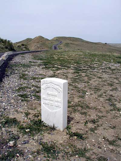 I take it that you will contact NPS and tell of their mistake with the marker. |
|
|
|
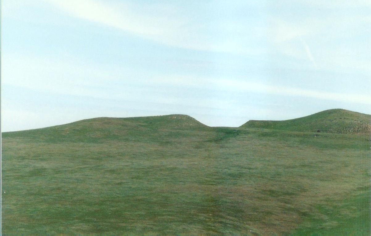
Post by herosrest on Nov 5, 2023 6:49:24 GMT -6
I'm terribly (and awfully) sorry about this but just have to ask if you think that the horses are stood on the highest hill, the very highest hill around? linkOf course they are, aren't they? Here's a better view - 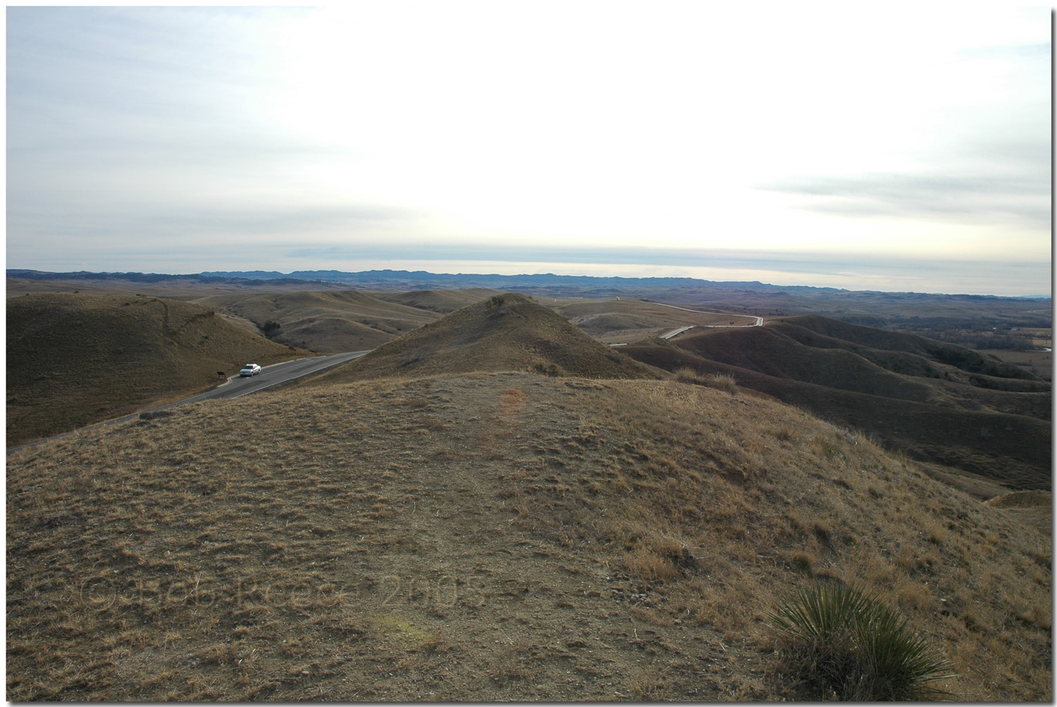 This is about the highest hill. Not what Martin or anyone thinks, said or demolished. It's the highest , yes? |
|


 ? 🤗
? 🤗


 . Camp did as you and many have and are which is try to rationalise disparate oral and written accounts of events, to the terrain. So........... what did and has this resolved? Nothing, because the history is not about what happened.