|
|
Post by johnson1941 on Nov 15, 2023 6:14:13 GMT -6
Why do you keep posting maps with digital changes? Oh never mind, P-shop - I know why.  You be you - by all means, - YOU go with tampered evidence with added little perfect circles with added typed perfect letters and numbers; at least 1 where where no number existed on the original!
Come on, now. Stop wasting our time - do better. Meanwhile...  The original is quite fine, thanks...and real.  I recommend you do NOT rely on Camp alone - he helps of course, but stand-alone is not conclusive. Witnesses. Testimony. Maps (unaltered). Pictures. 1st person narratives. Facts & Evidence. Corroboration. |
|
|
|
Post by herosrest on Nov 15, 2023 16:26:03 GMT -6
No one of Benteen's battalion, arriving to the bluffs and uniting with Reno's command - had any idea whatever about where the men with Reno arrived on the bluffs. It's a simple reality and one beyond WMC and his investigations of what happened. Martin spent a day looking at his highest hill whilst under cover being shot at from it.
Benteen arrived first or Reno did?
How about working out what actually happened before swallowing WMC's measurements hook line and sinker. That would be wise. Exceedingly so.
|
|
|
|
Post by herosrest on Nov 16, 2023 3:25:18 GMT -6
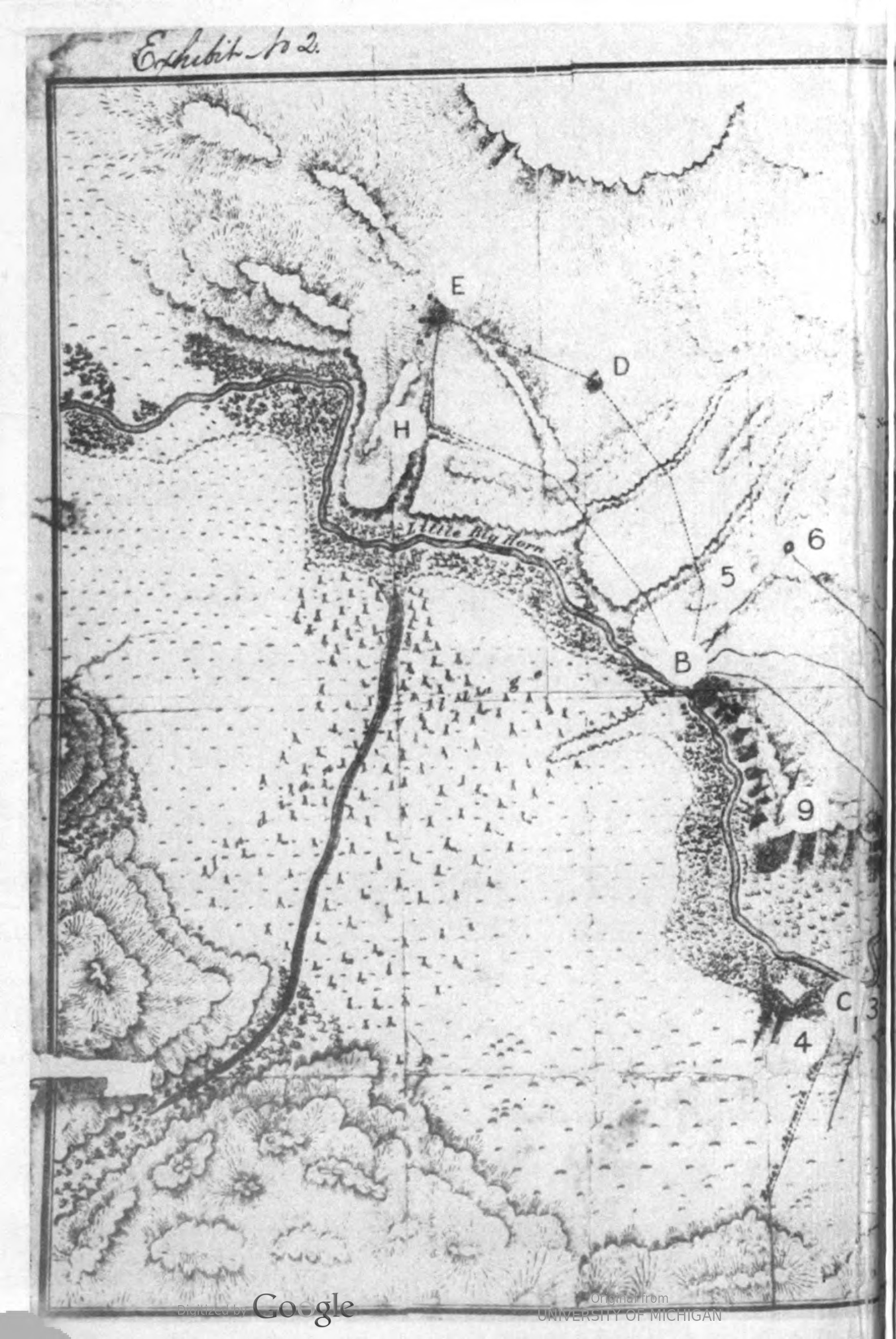
I believe that it is time (worthwhile) re-issuing Maguire's map. One of the early ones and perhaps 'the' earliest for he certainly was not contructing detailed work such as that which emerged later from St.Paul such as the tracing by Gillespie. Who? Erm.. His boss........ He left the expediton in the field and returned to..... St. Paul fairly quickly for valid reasons. Capt. Benteen was also re-assigned from the expedition and made his way to St. Paul. So, Lt. Maguire's early map -  Well done Ed. We know at least that the Cemetery Ravine played no part in the Custer Battle which you found on the ground two days after. There will be students of the battle who doubt this to be Maguire's work...... They should know me better. Maguire's sketch map. There are others. Here, ia an adaption of the 1879 model map with its quite brilliantly fantastic penmanship which might not go amiss adorning a wall in the Louvre's galleries of splendour. I have my own take on the smiling beauty, somewhere or other, from years ago in updating the meme into late 19th century Cadwallader of the US family branch. Welch King be damned............ Back on yor throne, Boyo! Sit....... My God, the pheasant are plumping nicely. We'll be out after ptarmigan on Boxing Day! Good lord, bit of a mess, is it knot. So, why was Benteen in St. Paul within weeks of the end of the battle? Where was Owen Hale? What information had he given to the family newspaper in New york.... They ran the Herald, you know. Oh yes...... Now, perhaps we should turn our attention the the frog up a pump, issue? Seven down - A genius in the wings.............. (four letters) Now, we come to digital changes. The map you exampled, is on file with LoC. It originated with JAG and passed into the public recoed. I'm sure that I mentioned this recently somewhere or other. So, the intimation that I have resorted to doctoring documents and images that underlies your snipe, is rubbish. Check your sources please and do not belittle the US Congress. They tolerate that soet of thing for a little while but not too long. Theseare the records with which W.A. Graham produced his works of opus (is it 'opussity' ?  . Knew a thing or two did Graham, but not all of it and grounded in very early 20th Century wango- wallah. He was such a card. Cope with reality - do not smack it down so your tail can swish side to side flicking in the breeze beneath. It seems that Bing's co-pilot has fallen in love with a squirrel. Cute little thing it is. It plays for the Vikings  Attachments:
|
|
|
|
Post by herosrest on Nov 16, 2023 3:54:55 GMT -6
Flap.
|
|
|
|
Post by herosrest on Nov 16, 2023 3:59:56 GMT -6
Yes, I went back and checked the foreward by W.A. Graham in the M.A. Reno book about the battle, which was published posthumously. Very good read.
|
|
|
|
Post by herosrest on Nov 16, 2023 4:05:15 GMT -6
|
|
|
|
Post by herosrest on Nov 16, 2023 4:42:53 GMT -6
Notice Google stamped to the image above. Perhaps you'd care to raise IT with Mr. Data. However, let's go back to the smudge, oh yes it is. Smudge which you invent into whatever adaption of your theory is current. Vincent Charley died over a half mile away from his marker and we know this from someone who knew where he died and knew from where the remains were disinterred. It's a smudge and not '5" linkBased on your observations two more '8' exist, another '6' exists. Brilliant. I wonder from time to time, if you have read King's reasearch and published maps in 'Massacre' - published by Uptons, I think it was. He goes way too deep into Patterson Hughes conspiracy stuff with maps and of course, Graham followed in PH's steps quite tightly in the Military Legal branch. You know, PH managed to thoroughly 'P' off Miles when both served on the board which published Hughes paper on the battle, which Graham included to his early publications. Getting hold of copy of that stuff is a real artform. It was Hughes article to the press in 1890, which kicked everything off again about disobeying orders. Did you know that Reno was relieved of command at Rosebud, after the recon to the Tongue of the Powder? Oh yes he was....... Naughty Marcus. Make him suffer. It seems that Custer thought he should have located and attacked. As it turns out, he would have run into Crook in advancing beyond Big Muddy, or stumbled into the czmps moving down Reno Creek to the Ford A area, where they turned upriver and camped east of the river from ford A on up to the mouth of Long Otter Creek, where the town of Benteen was established at the railway halt. |
|
|
|
Post by johnson1941 on Nov 16, 2023 5:24:45 GMT -6
Oh SO Martin was lying when he said all this?: A. We kept on General Custer’s trail, and after we got on this ridge where I saw Major Reno fighting in the bottom.
About this time we got there I saw Major Reno’s battalion retreating to the same side of the river we were on.
Q. 3/4 of an hour after you joined Captain Benteen you came back to the place where Major Reno made his fight on the night of the 25th, and found the men retreating up the hill?
A. Yes, sir. That was the time when we got on the ridge and saw the men retreating from the bottom, and then we halted there.
A . The men were retreating at the time we came there.
Zzzzzz. Come back to us, HR. YOU ARE LOST! Smudges indeed. Strangley that looks just like a 5, located right where it is described. And NOT at all near where someone later stuck a dot/typed a 5 who knows when, on a big blank space in the original.Original REAL source. Yes - Libary of Congress. Maguire's Map, exhibit 2, as used & HAND-marked by ACTUAL witnesses at Reno's COI. 👌👍 Point 5 & 7 marked near each other....on the bluffs - right where the highest point was. Where Reno went. Where Custer went. Where Edgerly went. Where Weir went. Where Benteen went. Where DeRudio was. Where Martin was. Where Camp & Godfrey were. etc. etc. LOTS of stuff happened there. Confirmed. Corroborated. www.loc.gov/item/2011525466/ We get it - you don't like WMC. So again - I recommend YOU do NOT swallow Camp alone. His measurements? He was a surveyor - very good work, often easily confirmed. Corroboration. Confirmation. Fortunately we have A LOT. He was going to that highest point when I went away {point 5}
{Point 7} was the highest point around there. I went on the top of it afterwards, on the 27th, with Captain Benteen
the command started down a ravine to get off the bluff {point 8}, somewhat to the right of highest ground
He did after we had reached that highest point at the figure “7”
the furthest point reached by any company under Major Reno was about half a mile below that highest point {point 7}
I moved to the summit of the highest bluff, but seeing and hearing nothing sent Captain Weir...
Captain Weir had to go back to the rear by a ravine before he could come to the position occupied by Major Reno's position/column on the hill marked “5”
etc. etc.

|
|
|
|
Post by herosrest on Nov 19, 2023 10:24:29 GMT -6
You believe you can do better than Reno and Graham, so............. play on. Meanwhile - for your coffee break. This may or may not presen and if it does, may not ne as intended but hell........... let's grow a couple of hills. LINK >ps I'm not certain but if you sign into your google or a google account to view the link, you get a few additional options (maybe). |
|
|
|
Post by herosrest on Nov 19, 2023 13:08:11 GMT -6
|
|
|
|
Post by johnson1941 on Nov 20, 2023 9:26:41 GMT -6
I'll take a "smudge" that just happens to be in the shape of a '5" right where its described to be, instead of...vapor...nothing...nada...  5? what 5? Oh THIS one!...  As always - YOU do you. |
|
|
|
Post by herosrest on Nov 20, 2023 14:32:53 GMT -6
I have had a word with specialists in the field and an EA-37B from Tuscon is going to search the area in working up its new electronics suite in the hope that Cheyenne smoke talk can be detected to solve this vitally important height issue. They will also look for signs in the ground of the initial 1876 campsight lovation. It is now referred to as a lovation since the tribes came together to dance. And boy oh boy, they danced the dance. i0.wp.com/militaryleak.com/wp-content/uploads/2023/04/ec-37b-compass-call-electronic-warfare-1.jpgHopefully that link of a highly secret compass call strike aircraft will be appreciated. Bon jour. |
|
|
|
Post by herosrest on Nov 20, 2023 14:40:16 GMT -6
 Howna! I have just been told that these things are so secret that they paint them grey. EA-37B |
|
|
|
Post by herosrest on Nov 20, 2023 15:13:23 GMT -6
Drat. Sorry about all this... Quad9 just went bananas besides my browser switching to Russian language.
I agree that the various incarnations of the maps are chaotic and may be interpretive post mortem but then they may not. We simply don't know. One 'could' assume that WAG was above reproach but then of course he did have a strange obsession or two and those very odd late 29th Century peculiaraties which the early 20's tweaked so well. It's a jumble of jelly fudge and just don't get me started on WMC who may or may not have seen the pre 1925 stuff. WAG was just sort of getting statted then, running around hunting down and up, Martin and the last message and getting his 1926 article on the battle together replete with copying Brinonstool's falsified image of Bouyer which they both published. Pooh in. Pooh out.
Obviously a copy of the original 1879 map would be cool but.... Have fun with that.
Hell, maybe WMC photoprinted it.
|
|
|
|
Post by herosrest on Nov 20, 2023 15:16:41 GMT -6
How do we know that it was WMC who photo imaged his maps? As in blueprinted them. How do we know?
When did blueprinting begin?
|
|


 . Knew a thing or two did Graham, but not all of it and grounded in very early 20th Century wango- wallah. He was such a card. Cope with reality - do not smack it down so your tail can swish side to side flicking in the breeze beneath.