|
|
Post by herosrest on Jul 15, 2023 13:34:33 GMT -6
The problem for me with the maps, is reconciling Maguire's early sketches and particularly that sent with the 1876 report, with the later work done on them at St. Paul and then where ever else for the later maps. Wilson was ordered out there in 1879 to mark out the intended battlefield and Ft. Custer reservations besides Ft. C.F. Smith also and was delayed a while waiting for wagons at Ft. Custer.
How much of the lithographed mapwork was Maguire's is moot since it is only assumed (as far as I can see) they were 'all' his work. In terms of the tactical fight of 25th June, the attached map clearly shows a route which is he Luce, NC, Calhoun Hill corridor and erm...... no-one, except possibly Freeman, discovered evidence such as cartridges which turned up 52 years later discovered by Blummer. It is a big problem and particularly because of the shifting sands upon which understanding evolved.
The terrain feature which cannot be ignored on the maps is the Gresy Grass Ridge, Calhuon Coulee juction with Deep Ravine. It was consistently used to identify the location of the ravine in which the 22, 26, 28 or 30 men perished. It is all there is to really go on - however, the field was cleared of remains and horse bones on numerous occaisions from summer 1877 onwards, and what was left behind in 1878 when Miles visited may not have told the entire story and probably didn't. Reed's scalp is in a museum collection somewhere with considerable doubt his body was ever located. In 1877, the marker for Boston Custer was hundreds of yards from Custer Hill and that is from an entirely reliable source, who was there with one of the Sheridan's - John G. Bourke, so I guess it was P.H. Sheridan. It's a complete utter mess the further from the early accounts that time travels and by two and half years it was verging on fairy tails at Chicago. That's difficult for military to grasp or swallow but doesn't make it go away.
There were not 28 bodies in a pile to be buried. A ravine side was chipped off from above because men McDougall sent in to do burials were puking their guts up within five minutes. The idea that a ravine side was collapsed over 28 bodies is simply wrong. Theory based upon the concept is fatally flawed - excuse the pun.
|
|
|
|
Post by johnson1941 on Jul 15, 2023 14:24:22 GMT -6
Good stuff.
I did read someone - maybe Godfrey - saying Boston was found about 200 yards away from Custer HILL - not just 200yds from the brother George, so I buy that marker local.
"GENERAL GODFREY: A LETTER TO E. S. PAXSON
Boston (Custer), the youngest brother, was dressed similar to the other brothers, his body was found about two hundred yards from Custer hill, between that and the Little Big Horn, at the foot of the ridge that runs up from the river as it were, forms the lower boundary of the battlefield. The body was stript except his white cotton socks and they had the name cut off."
Harper, Gordon. The Fights on the Little Horn Companion: Gordon Harper's Full Appendices and Bibliography (p. 2307). Casemate Publishers (Ignition). Kindle Edition.
|
|
|
|
Post by herosrest on Jul 15, 2023 16:16:25 GMT -6
I'm thinking about going into an area of more recent study on the ground after 1983 and one of the conclusions which really pulls the rug (for me) under one of the current developments of the tactical fight. If I can pull it together tomorrow i'll pop it up. First I need to pull together an insight with Montana Columns' advance onto the retreat ford. It's Ford D related since through an interpretation of early evidence supposed tobe on the ground west of LSH. That of course is the start of the Cheyenne way into Deep Ravine for Company E.
It's been a long day where I had intended visiting the local beer festival but weather warnings were issued for high winds and I ducked. It was a good warning.
Regards.
|
|
|
|
Post by herosrest on Jul 17, 2023 5:54:20 GMT -6
|
|
|
|
Post by lakotadan on Jul 18, 2023 8:24:01 GMT -6
![]() Hello all! So, back to the “Forgotten Ravine” as stated in some of my previous posts to this thread. What originally initiated my search for this ravine was the Maguire map of 1876 which shows an area marked "H" and a ravine type feature coming off the right-hand side of the Cemetery Ridge ravine (or coulee). That map is also included as the last attachment to this post. Let me try to provide some evidence for my thoughts. First, is the aerial photograph taken in the 1930’s which shows a ravine feature (can’t argue with photographic evidence!). I have added blue lines and circled a “bowl type” feature that makes this ravine easy to find on the other pictures listed. Then there is the picture of the current google map that shows that same ravine feature filled in (marked in blue). I figure the ravine was probably filled in around 1950 for whatever reason (the site became a National Park in 1946). Now follow some descriptions of “eyewitnesses”- I remember reading about a description by Capt. McDougall to Walter Camp in 1909 that states something like McDougall pointed out to Camp where he saw and buried the 28 bodies. They were in a prominent bend in the ravine. If you look at the google view (attached), you will see where there is a definite “prominent bend” in the “Forgotten Ravine” (marked in blue). On YouTube there is a video by a park ranger about the “deep ravine”. He states that they know exactly where the bodies have been buried because Camp with Kanipe (in 1908) surveyed the area. The ranger also states that Camp stated (after taking his survey) that it is exactly 2100 feet from Last Stand Hill to where the bodies are buried. So, I mapped it out on Google. As the “crow flies” it is 2095 feet from LSH to where Camp said he saw the 28 bodies. Now, I believe the “Forgotten Ravine” probably drained into an area that is only about 100 feet east from where the ranger stated the bodies were buried. That distance is about 2039 feet from LSH. So, a difference of about 56 feet. That is well within a 5% variance of the original distance measured by Camp as about 2100 feet (I calculated it as 2095 feet to Camp’s 2100 feet). Well, a “miss is as good as a mile” when trying to discover where the 28 bodies may be buried! I also remember reading about a Native American eyewitness that stated the soldiers in a ravine were the last to be killed. He stated something like it was as though the soldiers were shooting their pistols into the air. Well, if I was in a ravine that was probably 5 to 7 feet deep and 3 to 5 foot wide the only way to shoot would appear as if I am shooting up into the air! I could not aim my pistol in a diagonal line because I was in a ravine with steep sides. So that makes sense to me! It seems to me that this “Forgotten Ravine” just “fits” into the missing pieces of the puzzle of what happened to those 28 (or less) soldiers remains. It is my belief that visitors to the battlefield have been walking directly over the “Forgotten Ravine” (via the deep ravine trail) for around 73 years! Anyway, the above are just some more interesting thoughts on the “Forgotten Ravine”. Again the "Forgotten Ravine" may just be the “missing piece” of the puzzle where the 28 (or less) remains of the soldiers are to be found (if there are still any remains there!). First, we have the aerial photograph taken in the 1930’s. Then we have the “prominent bend” in the ravine. We have the surveyed distance to within 100 feet of where McDougall states he saw the bodies. We also have the eyewitness accounts of soldiers in a ravine “shooting up into the air”. We will see what the future holds! |
|
|
|
Post by johnson1941 on Jul 18, 2023 9:06:40 GMT -6
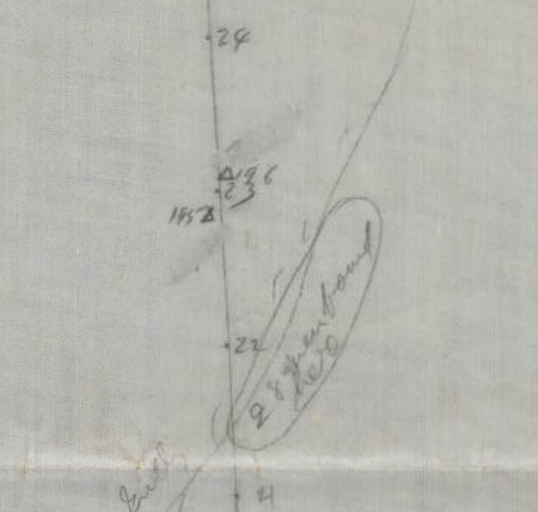
Ecellent detective work, lakota! I will read your post in greater detail ASAP!! Similiar to what I have been up to with other points of interest... Now - Check this out..this is/seems to be part of series of survey maps of markers done by Camp. From what seems to be the monument on LSH (pg 1), to the "28 bodies found here" (pg 2) is along a graduated line...the "28 bodies" are between "21" & "22" on that line...is that 2150'? Hmmm...exciting! Unfortunately the images are not to scale, but dollars to donuts if one could print them to proper size and connect them as they should be lined up, you could figure out the exact direction that graduated line is pointing. THERE IS A N/S COMPASS LINE ON THE MAP 1! {Those bodies are in a direction almost parallel with it}. AND place within reason where all the markers(?) are (one section is missing I think - but I know where that section is in another folder). contentdm.lib.byu.edu/digital/collection/p15999coll31/id/52251/rec/42contentdm.lib.byu.edu/digital/collection/p15999coll31/id/52252/rec/42Be sure - Camp was not an idiot - in fact it seems he was a railroad survey engineer, with lots of time invested, who located and measured most of the cool stuff to great detail - often with the people that were there. He answered many of the questions to good satisfaction over 100 years ago. Want to know where the Lone Teepee is? Curley showed him and he marked it. The morass? Yep. Benteen's route? Yep. Crow's nest? uh huh. Weir's Hill? sure thing. Where Custer hit the bluffs? Check. Height of Edgerly Peaks? OK. Distance between Custer's Camp at 2:30 on the 25th and Reno Hill? Got it. 28 bodies found in a ravine? sure seems like he thought he knew. Attachments:

|
|
|
|
Post by johnson1941 on Jul 18, 2023 9:53:28 GMT -6
Lakota - for reference - 2100' (due) south of the monument... Get a better bearing, make sure you're in a gully and not on a peak - & Bobs your uncle! Attachments:
|
|
|
|
Post by lakotadan on Jul 18, 2023 10:28:47 GMT -6
Hello johnson1941 and thanks for your posts!
So, I went to google and measured it again using their measuring tool.
2026.86 ft from LSH to end of “deep ravine” trail (yes-I was in a ravine!).
1939.10 to an area about 160 ft east of the above end of “deep ravine trail” (where I think the “Forgotten Ravine” could have emptied into “deep ravine”).
So, still within a 5% variance.
Who knows? Maybe McDougall saw the bodies in deep ravine, and they were moved slightly to the “Forgotten Ravine” where it was easier to throw dirt on top of the bodies?
Or maybe Camp was off by a couple of feet or used a slightly different part of LSH to start his measurements?
I don’t know, but I still think a search of what I call “Forgotten Ravine” would be an interesting place to search for possible remains!
Not only that, but another question is what part in the battle could “Forgotten Ravine” have played?
Let’s say the "top" of the ravine (the “bowl shape feature”) is on the top of a ridge and the “ravine” features were running off the left of the ridge into Cemetery ravine and the right-hand side was running off the ridge into “deep ravine”.
If Custer saw the ravine, would he attempt to cross it perhaps going down to the river at Ford D? Could (tired) horses jump over a possible 3- to 5-foot-wide ravine?
Maybe that is why on one map I saw it showed Custer’s route to the river going around the north side of Cemetery Ridge. Maybe he wanted to avoid the “Forgotten Ravine”.
All interesting stuff! That’s what makes this battle so interesting to study!
|
|
|
|
Post by johnson1941 on Jul 18, 2023 11:21:12 GMT -6
And more FYI...the specifics about Kanipe & Camp re: distance to bodies... Knipe 1908, 1909 "I next went along the line of dead bodies toward the river, and riding along the edge of the deep gully about 2000 feet from where the monument now stands, I counted 28 bodies in this gulch." " About 2000ft"?!? Anything with a few hundred feet of this comment is fine!! Camp used odometer carts, and he usually tells you what the distance per revolution was. A bit of advice - TRUST NO ONE!  Find the source, 'cause people - even park rangers, and numerous authors, love interjecting their notions...find the primary source whenever you can! |
|
|
|
Post by herosrest on Jul 18, 2023 12:04:27 GMT -6
Amongst others who noted and sketched the supposed ravine, was Capt. Freeman of 7th Infantry. I think he marked it '7' on his sketch map and notes about it. Freeman's Journal. It took a hundred years to get it published, you know. The original pages, including sketch and notes, are online at Yale. I'm just mentioning it, as I have for many years. However, I would like to know how you arrive at a bunch of bodies buried in a ravine. Are they individual bodies scattered about, or a pile of 28 bodies? |
|
|
|
Post by lakotadan on Jul 18, 2023 12:10:45 GMT -6
Thanks again johnson1941!
So, "about 2000 feet from where the monument now stands". Yes, I would consider 1939.10 feet within tolerances! And you are correct! That already brings down the distance by 100 feet (from "the about 2000 feet") from what the ranger stated on the YouTube video, he stated 2100 feet!.
Now, I am satisfied to use anywhere from about 1800 feet up to 2000 feet for the "burials" in the "Forgotten Ravine"!
The research continues!
|
|
|
|
Post by herosrest on Jul 18, 2023 12:19:47 GMT -6
Here's R.A. Fox's take on Freeman's map and it is the reason I became so completely PO'd with the guy. link. An entire Chapter of dreams (Chapter 11, Cemetery Episode) based on nothing but suppositions based on suppositional notes, and complete abuse of Freeman's sketch such that no-one takes it seriously.  Freeman marched in leading the Infantry battalion with Terry. He was never at Fox's '1' but was at Freeman's '1'. The '1' Freeman marked on his map sequence of numbers. Freeman's original goes into a bit more detail than Fox could be bothered with. Adapted............. adapted from............ wow. Yo Maomma! Freeman rode in with Benteen, Company H (14 men), Terry's staff and scouts and others, on 27th June 1876. He found Keogh's body before Benteen. Benteen went UP Crazy Horse gulley. Freeman obviously did not. |
|
|
|
Post by johnson1941 on Jul 18, 2023 12:56:32 GMT -6
HR is the Fox book you refer to the
ARCHAEOLOGY, HISTORY, AND CUSTER'S LAST BATTLE?
|
|
|
|
Post by herosrest on Jul 18, 2023 13:18:32 GMT -6
Yes, Chapter 11 when the fraternity were flush with the results of 1984 onwards and things got.............. stupid. Yale H.B. Freeman Sioux campaign journal.pdf (749.69 KB) Chapter 11 works over theory for Cemetery ridge along the lines, there is no proof and so that is the proof. Same since all the way west to the railway bridge now. You have to take the chapter notes in, which are used to justify some real jabberwocky. This is the same thing link unfolded here. Here's one of the lesser known White Bird pictograms... well, a detail from it. He was a scout at Fort Keogh. Cheyenne, I think........... fought in a few battles. 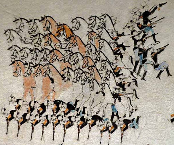 |
|
|
|
Post by johnson1941 on Jul 18, 2023 13:49:48 GMT -6
On edit: Oh shoot great link!!!
Thanks - I'll keep digging for specifics - trying not to cough up the $$ for the book!
So far I found, related...
pg351
THE FIELD ARTILLERY JOURNAL
These letters of Lieutenant Paulding describe in detail what
Gibbon's column found on 27 June. 1876:
Terry's Indian Expedition
Camp on Yellowstone mouth Big Horn
July 8. 1876.
My dear Mother:
On the night of the 2nd I wrote you about the Little Horn affair
but had not time to finish before the steamer left with the mail. A
courier leaves tomorrow so I will endeavor to finish the account. I
believe I got as far as our arrival at the site of the Indian
encampment, where we found signs of the recent battle. As we
proceeded up the valley we found a lot of dead Indians lying on
scaffolds, under trees & in 2 lodges, saw nothing of any white man
except a very few bodies & some heads, evidently dragged from a
distance. The bodies may have been of wounded or captured men
tortured.
Our small party of scouts from across the river sent word
that they had just found 28 white soldiers lying dead in a ravine
crossing the bluffs opposite & a mile or two behind where we then
were. Soon after they reported a total of 196 which afterward swelled
to 204 dead, all except the first 28 being found along the summit of
the bluff and about 40 in one group which was on a little knoll higher
than the rest where they had made a last stand...
...
The dead were when found almost entirely stripped,
slashed up & mutilated so as to be hardly recognizable. The officers
were Gen. Custer, Capts. Keogh, Cooke, Smith, Yates & Custer,
Boston Custer, Lts. Porter, Sturgis, Riley, Harrington, Crittenden
& Calhoun, Dr. Lord, a friend of General Custer, Mr. Reed & the
Herald reporter, Mr. Kellogg. I did not see any of these as they
were buried where they fell & during the 2 or 3 days we were
there I was too busy with the wounded"
|
|


 Find the source, 'cause people - even park rangers, and numerous authors, love interjecting their notions...find the primary source whenever you can!