|
|
Post by lakotadan on Jul 14, 2023 7:48:30 GMT -6
Hello again johnson41! No, it is not #3 in your attached photo. It is further east then that (about in the middle and slightly to the left of your #4 line). What I was able to do is I took a picture of google maps. Then printed it and circled the area I think the "Forgotten Ravine" is. Then I took a picture of the google printout and it is attached here. I also attached a picture of the "dip" in the "deep ravine" trail between the markers I think the "Forgotten Ravine" is (on my recent and super fun trip to the battlefield!). It is the last picture. It was taken looking "up" towards where the trail starts just east of the visitor center. If you check out google maps (zoom in) on that area you can discern where it is. Oh, and please disregard the other 2 pictures in the middle. I don't know how they got in there! |
|
|
|
Post by herosrest on Jul 14, 2023 8:06:23 GMT -6
Some thoughts on the infill matter. During Luce's tenure, a series of works were undertaken to lay in services and improve access. A water supply was laid in to a water tank which is the base of the modern Native Memorial. Trenching the supply discovered a horse bones cemetery. Below riverside, a pumphouse, sump and the pipeline were installed together with electric supply and phone line junction up to the Stonehouse complex. Somewhere in the vicinity of the admincentre (stone house) petrol tanks and supply lines were put in.
There may have been surplus soil from burials deposited elsewhere than graves and it 'seems' some levelling of the national cemetery land took pplace together with the tree planting. That is just with Luce. He was followed by Rickey and the improvements undertaken during the 1950's.
I remember an article or topic from way back which worked on the idea of a trash dump somewhere west of LSH. I mention this stuff simply to point out things that you might keep an eye for if youbury in reading and research. For example, there will have been annual litterings of theground and trash from the Admin center which is hardly the stuff of dreams or battle books but is in their in vague and oblque records, accounts and records.
What did happen to 100 years of feces from the Admin Center. What happens with it now?
Hmmm..... One for Ranger Donahue?
|
|
|
|
Post by herosrest on Jul 14, 2023 11:20:07 GMT -6
This is an interesting visual anecdote which in somw part, gives view of the terrain. It is ancient video of some doings and I spotted some of the usual suspects - Curley (great smile), Godfrey, Tom LaForge and probably others but i'm still rubbing my eyes. It seems to be 1926ish which is problematic since dear old Ashisheshe passed away in 1923. However, I happen to know that wibbly wobbly was being filmed on the ground a while before 1926. There seem to have been quite big bashes in 1921 and 1916. There were large gatherings in late June from the earliest 1900's. Was that Curley in his Police uniform? He looked pretty smart  Of course there were the Crow Fairs going on also, and the new continental roads and railway before that to ship people in and farm produce out. It might be possible, to identify the four guys in the car.......... wow, if it is 1926. Well I never.  Maybe some of the footage is from the bashes at Sheridan...... drat..... Is it really Curley.... aaaah... |
|
|
|
Post by johnson1941 on Jul 14, 2023 11:34:11 GMT -6
Think I got it - its about 1/2 mile from the river - maybe see witnesses statements on how far from river or hill they saw the bodies? Congrats on your trip there - must have been sweet! Attachments:
|
|
|
|
Post by herosrest on Jul 14, 2023 11:37:50 GMT -6
Another thought on this bones of the battle issue. An early 1900's image of Bone pickers. The next picture is of the cemetery. I am not connecting the two images other than in erstwhility. |
|
|
|
Post by herosrest on Jul 14, 2023 12:00:37 GMT -6
An interesting ancilliary read on the battle's peripheral events and by an author who just might have injected a little here, and a little there, but addressed matters rather well for the time - given those available to his research. Sgt. Caddle of Troop I, is priceless. Conquest |
|
|
|
Post by herosrest on Jul 14, 2023 12:09:21 GMT -6
Pump it up. 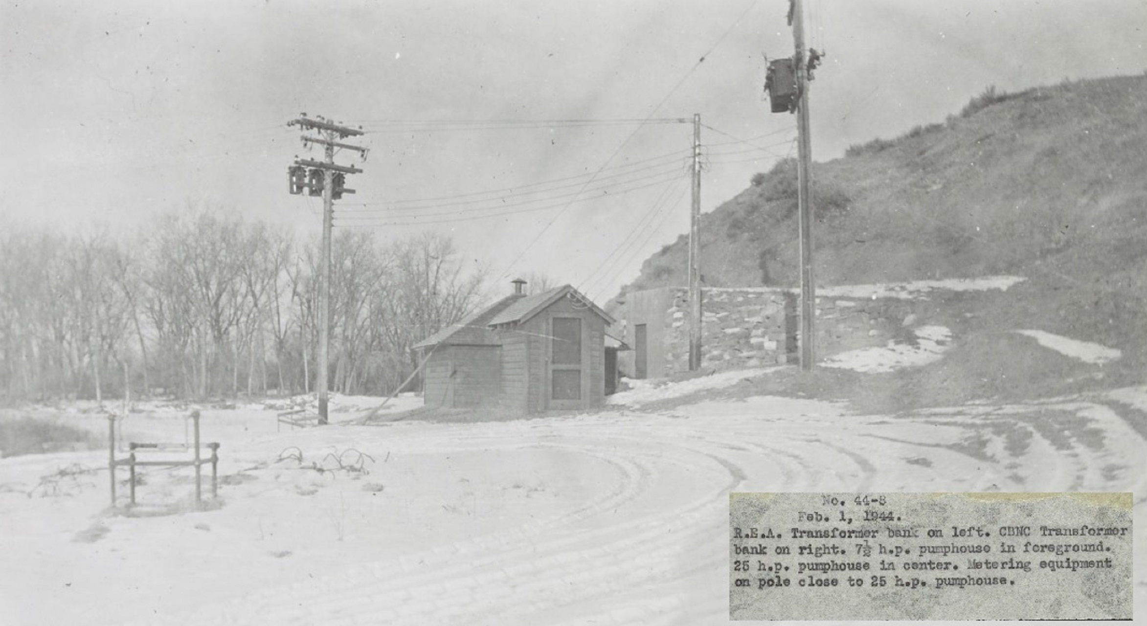 Ancilliary services below Custer Hill and the Stonehouse on the river, circa 1941. I suggest, that,if you can pinpoint thosestructures at the river then it may be possible to fathom where bodies are buried at the cemetery. |
|
|
|
Post by lakotadan on Jul 14, 2023 12:11:11 GMT -6
Hello johnson41!
Yep, you nailed it! That's the place I think the "Forgotten Ravine" is! Hurrah! I wonder what other members will think about it, could there still be remains buried there (maybe in that "Forgotten Ravine" closer to Cemetery Ridge coulee?).
Yeah, my trip to the battlefield was great! One more thing to cross off the "bucket list"!
|
|
|
|
Post by herosrest on Jul 14, 2023 12:44:18 GMT -6
You'll find that battle author Robert Nightengale, once of the valley, has posited a similar theory based in re-interpretation of one of Maguire's later maps of the battle. There are a couple of books and the second deals with the location of the supposedly missing remains. That is the 'Mystery of Sitting Bull' work. He felt so strongly that the map was misinterpretted that.......... the matter was officially complained. To the U.S. Army........... and..... he held his breath waiting for the reply. 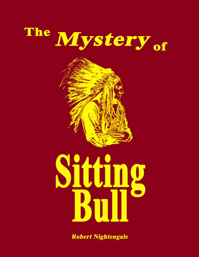 Hey robb, how're ya doing? Robert Nightengale's latest book, The Mystery of Sitting Bull, recounts the Battle of the Little Big Horn and the events that led to the defeat of General Custer at the hands of the Great Chief Sitting Bull with his thousands of Indian Warriors. In it, Nightengale re-introduces the 1876 Maguire Map, drawn just two days after the Battle of the Little Big Horn, while the bodies were still being buried. Engineering Officer Lieutenant Edward Maguire drew a map of the battlefield with assistance, an odometer cart and a prismatic compass. This map has been forgotten and never referenced by authors and historians and reveals startling new evidence on Custer’s Last Stand. The forgotten 1876 Maguire Map identifies a hidden position on the Custer Battlefield where Chief Sitting Bull and his thousands of Plains Indian Warriors planned on ambushing General Custer and the 7th Cavalry. The forgotten 1876 map drawn on the Custer Battlefield only days after the historic battle, also proves the location of “Deep Ravine” is mismarked in the wrong location at this historical battlefield site. And finally, Nighengale reveals a lost message proven to be a last desperate message from General Custer sent from Custer’s Last Stand.
With 701 pages, over 1200 primary source quotations, including 620 illustrations and maps. This historical subject becomes the true adventure story, a retelling of the legendary defeat of General Custer and his brave 7th Cavalrymen and the Great Chief who prevailed over them, the Great Chief Sitting Bull. This is a 'must read' for everyone who thought they knew the real story about the Battle of the Little Big Horn. The controversy still lingers today and there will be those who disregard these recently uncovered facts, as Nightengale pulls back the curtain of the accepted paradigm of one of America's most historic events Custer's Last Stand. Read The Mystery of Sitting Bull and discover the adventure for yourself.
Now, a final final message that is unknown of..... brilliant, except that I have seen it. Really and it is definately Custer's handwriting. Go figure.......... Some of his Youtube link |
|
|
|
Post by herosrest on Jul 14, 2023 12:57:17 GMT -6
Some of the images on file with Yellowstone NPS - linkSOURCE - search to your hearts contents, besides the obvious, try Condon. Custer Battlefield, helps......... Regards. |
|
|
|
Post by herosrest on Jul 14, 2023 13:19:48 GMT -6
|
|
|
|
Post by herosrest on Jul 14, 2023 13:33:52 GMT -6
|
|
|
|
Post by johnson1941 on Jul 14, 2023 15:43:57 GMT -6
HR, didn't you address that Nightengale re: MaGuire map "conspiracy" way back when? The Maguire (actually Becker) map, the Maguire sketch, the Gillespie sketch that is a tracing, the Gillespie map that is a tracing... Any real conspiracy there to be interested in, or just later takes and attempts to improve on the information Becker tried to show? Attachments:

|
|
|
|
Post by herosrest on Jul 15, 2023 11:58:40 GMT -6
I delved back for a topic of yore which came to mind...... next time your bored....  Click the smiley. I guess that Nightengale got hold of the 'Massacre: The Custer Cover-Up' book and maps by King, or maybe Donahue's and dragged up old theory from a possible plethora of sources where students of the battle were unsatified that a pile of bones could not be found. Besides Becker undertaking map making, which job had been M cClernand's as Gibbon's EO; the Engineering party aboard Far West were mapping as she ran up the Bighorn past the mouth of the Little Horn. That was Sgt. Wilson..... of the 1879 map naming MTC as Reno Ck. and indicating also, Yates Creek. He seems to have had reliable chronometers with him which is one of those anecdotal trivia I never resolved. M cClernand was Cavalry and not engineering trained so why would the column from Ellis carry fancy clocks? Anyway, I was analysing the Maguire derived maps and noticed a thing or two about terrain which really shed little light on the battle but are the sort of earthshattering revelation I tend to let lay. Yes, I contemplated Nightengale's take on the matter because he was obviously serious or pulling publicity stunts. He and the battle have a bit of a history but again.... so what.I don't think the Feds are going to give up their secrets. Onwards...... Sorry, SWMBO just arrived. Erm..... the St. Paul version's of Maguire's map, derived somehow from 'two sketches of the terrain which were knitted together in the HQ Offices, where for example the Gillespie tracing took place. He was the Engineering Head honcho at St Paul which was Terry's centre of gravity...... Oddly, Benteen turned up there fairly quickly which is documented here and there. Maguire dived overboard from the expedition also, hence the early Curley story of the battle from Helena. First Story. added - Originally and for a while, the river was to have been called or re-named Custer River but quietly drifted downstream. Hence, I guess, Yate's Ck. |
|
|
|
Post by herosrest on Jul 15, 2023 12:36:36 GMT -6
Per the second of your of your attachments above, the style of hatching the terrain in pen and ink or scribed onto metal plate, is all but identical to that HERE. Which is no particular mystery since Sgt. Wilson was on the staff at St. Paul when not deployed. His enlistment expired and I guess he was retained as a civilian employee and later, became a Second Lt. in 5th Infantry I think. It mifht have been 2nd Infantry. It was a rare thing. Definately the same hand on both maps. Wilson wasn't on the battlefield in June '76, as given, he was with Far West, Grant Marsh, Capt.Baker and the 6th Inf. company B, I think it was. With the Lt. whom Sellew delivered despatches from Custer to, on the 24th June 1876 after riding the Tullock. I guess he was there when Curley showed up with news of something or other which no-one understood. He would have been there when Brockmeyer arrived with despatches from Terry, and not finding the Far West at the river mouth because Baker had a 'magic moment', went downstream looking for the boat which had carried on upstream. Interesting geography on that terrain, it just repeats and repeats terrain features in all sorts of scales. Don'e sweat it, I know what I mean. See Powder River scout death. Yup, Wilson was on Far West, with Mulligan! |
|


