|
|
Post by herosrest on Jun 8, 2023 6:21:46 GMT -6
An anecdote - Why newly appointed LT's used to do the map reading www.rmg.co.uk/stories/topics/true-north-magnetic-north-whats-difference The US army Corps of Engineers were engaged in the same task of observations at the time of the battle, and the data was reported each year and assembled into tables. It was a matter of some priotity at sea and on land but obviously ongoing. The loss of his chronometers during the march from FAL in May -June 1876, seems to have put the wind up Maguire. |
|
|
|
Post by johnson1941 on Jun 8, 2023 6:25:53 GMT -6
 Ah yes - the one Godfrey used! Spring and all! Seems his point A is Weir Point...where 'some men saw custer'... And what may be Weir's Hill is REALLY prominent! (at bluff above "retreat") And North vs Magentic North...via Becker re: McGuire... Attachments:
|
|
|
|
Post by johnson1941 on Jun 8, 2023 6:38:32 GMT -6
I've just bumped the 1879 Wilson map, which is a lovely bit of art - belongs on a wall somewhere....  link link. Now.... Graham...... This is the reference link but the copy didn't copy the map. I have a copy of it somewhere on file and will endevour to find it. It was very odd with me researching the USAAF 36th Fighter Sqd, which operated out of Port Moresby in Early 1942, and bumping into the map in some god forsaken hole of the internet. I'm pretty sure I popped it up on one the boards and Wagner III went apoplectic over it. You know him, if the horseshoe fits, bend it. RiP. Lovely guy. From the Reno/Graham link...some intersting comments re: high points and coulees.. Benteen, Edgerly Edgerly |
|
|
|
Post by johnson1941 on Jun 8, 2023 7:02:41 GMT -6
This may be what you were attempting with "Graham"? Got this from an EBay listing... Attachments:
|
|
|
|
Post by herosrest on Jun 8, 2023 7:36:15 GMT -6
I'll mull into your inquiries and wonder where they are leading..... violently bloody destruction and mayhem three miles away perhaps. Becker's is one of the more interesting maps which W. Kent King published in his study of the various twists and turns. His work isn't mainstream and certainly not without malice but much of it deserved if point of view is pro-Custer which no-one was by the time he was getting ready to publish. Rather as with Harper who posted here, King's work was published post=mortem with the last chapter by battle stalwarts uptonandsons.com/cts.htm - The Original Maps of Custer's Battlefield (Custer Trails Series ; Vol 3) Slightly pre-dating Donahue. You'll find that the part of the river which cut into the bluffs and dog-legged south was 3-400 yards further downriver in 1876 with the oxbow closing during the 1970's to leave terrain east of the river, west of it and an area where quite a few battle related finds were discovered. This is shades of Dustin's dilemmas and changes of mind. I remain convinced that we and everyone before, have missed the vital clue and perhaps Vaughn understood more than he let on, in his chapter on the battle in the valley. Of course he was then present with Rickey for the John Stands in Timber interview and its landmark revelations. The CoEng. NCO's were a capable bunch of grafters, there was Wilson also, aboard Far West, who mapped out the Ft. Custer Military reservation and battlefield plot, in August 1879, as the best map available of what was what then, 2 years after the battle with an island in the river below LSH. The nuts and bolts of this boil down to White Man Runs Him and E.S. Curtis. It was discussed well in this topic lbha.proboards.com/thread/509/white-man-runs-statements WMRH was as unreliable as a kettle of kippers. |
|
|
|
Post by herosrest on Jun 8, 2023 8:20:09 GMT -6
Your copy texts,
Martin did not..... [Custer's own statement]
I suspect this 'should' read, 'Benteen's own statement' and given this, then we know considerably better due to Benteen's horn. The dilemma he faced when he detected Custer and Reno's trails diverging. Of course, Benteen was as unreliable as shifting sands and not up to figuring out what happened. Or if he did, was too cute to step into the middle of it once the acrimony began.
Note: We do not know who enumerated the map addressed and marked by those giving testimony at Chicago. That it was those giving testimony has a 50% practical chance of being correct. I doubt it was them because the process tends to witness such activity which is producing evidence.
'We moved out along the ridge to that Point 7...', is Edgerley, I take it. Not mush to say really. I sure would be very much happier with this battle if the relics found on Luce Ridge had been forensically examined and compared with those east of MTC up to and all over Reno Hill.
I have long felt that hostiles killed a huge number of snakes on the Custer Battleground.
In terms of the map used, those giving testimony did so in succession and without confering with colleagues, or anyone. Many who were called found fault with the map and stated so. Thus things got into best guess and that will do. Hare's stuff is interesting, 5 & 6 I think. I'm going on memory with the kitchen being cleaned around me, nibbling biscuits with tea and the TV very loud across the hall while no-one is watching and rather talking themselves stupid in 'I have mouth and can use it' fashion!
Regards.
|
|
|
|
Post by AZ Ranger on Jun 8, 2023 8:30:50 GMT -6
Oh I’ve never been there either. Yay google earth! 😀 And Camp left some great clues! Thanks for the infomation AND the great photo! Most of this is based on Camp, and a bit of Kanipe and Martin and Benteen and De Rudio and Curley etc. to back it up. Ha and luckily I can read and do basic vector math, and google helps with distance calcs. Seems pretty clear Camp's Weir Hill is NOT Weir Peaks or Weir Point (or Edgelry Peaks or Reno Peaks  . Per Camp it is 2500ft away from there, and only 1700ft from Reno's retreat up. SO YES - Fred's 3411 & near 1891's USGS 3500 and Camp's Weir Hill all jive - both in location and descriptions - as I've mentioned and shown in several previous posts. 3500 is a HIGH(est) elevation measured there before they put in roads etc. The most...fun thing was realizing all that when Camp starts with "Custer was on Weir Hill..." when he's w/Martin! THEN it makes sense!! And much else falls into place. Unless Camp was totally whacked out, and we know his map is off , his/Martin's Weir Hill is pretty easy to locate based on his bearings and distances. Knowing that actually made things a lot LESS confusing when reading 'testimony' when we get what/where he was talking about. |
|
|
|
Post by johnson1941 on Jun 9, 2023 0:41:37 GMT -6
“His Weir Hill appears to be the loaf that is attached to Weir and runs toward MTC. ”
If so then his map Is correct - but his bearings and distances are WAY off. As might be his hill vs others descriptions. Ugh!
But its the other way - too many witnesses identify Weir Hill.
|
|
|
|
Post by herosrest on Jun 9, 2023 12:38:18 GMT -6
Camp's work evolved conceptually. link We do not see what he he saw. Some say that whole entire knobs of hill have vanished down the bluffs into the river in collapse.  Here's something odd (for me) as the commentary has Weir arriving to his view at around 3:30-3:40 into the video, which coincides with what I figured out when I timelined the thing years ago. Plus and minus was 20 minutes because anything finer is ridiculus but I managed to hone it down into reasonable guidelines. This is why I find 'Strategy' so entirely amusing. |
|
|
|
Post by johnson1941 on Jun 9, 2023 16:47:29 GMT -6
“ The nuts and bolts of this boil down to White Man Runs Him and E.S. Curtis. It was discussed well in this topic lbha.proboards.com/thread/509/white-man-runs-statements ” This link was very helpful…seeing Varnum had placed seeing “E” further north along the bluffs - at 2 between 7 & 9 on the map - is good stuff! Seems a lot further along then where De Rudio placed Custer (7). |
|
|
|
Post by herosrest on Jun 10, 2023 7:41:01 GMT -6
This aerila image was used by Utley to give his idea of the movement. It shows the terrain quite well with the spur kicking south towards the river, The bluffs are a succession of little nobs rising above the water courses descending to the river flat (plain). Viewed from the valeey the usual trick of the skyline being a straightline is in play, when actually the terrain and its skyline kicks out into the valley from below Weir. 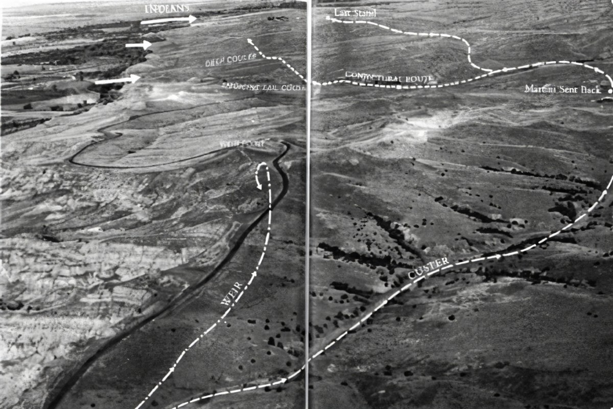 There is some video somewhere of Wagner III trying to point this out. The terrain is very similar to that along the route of the Battlefield road as it moves across and up North Medicine Tail (Deep Coulee) where rises and hilltops were graded (decapitated) for the smooth ride enjoyed today. The stretch from RBDS to MTC has been significantly altered along its immediate route, and was inventoried y Doug Scott in a project during.... the 1990's maybe... maybe later; when improvements to the original road were made. The engineers faced the same issues as Custer but also had to consider costs and land rights - so it was easier and quicker to go through the doughnut dip than romp down Cedar Coulee. Practical versus theoretical. My mind is a bit fogged but, I believe it was the army who built the original blacktop. From Sharpshooter on down to MTC - there are hills everywhere to front, real and both flanks. From the dimple in the terrain surrounded bt the weir-doughnut heights - if the terrain to immediate north could be controlled out to 1,000 yards - it was a far superior defensive position to that taken by Reno and Benteen. The if, is a big if with the carbines but no-one was going to be shooting 'down' into your lines. Attacks - uphill all the way. No water but that is true also of RDBS. ARZ sees it the other way with RBDS as a better position but you take the high ground and you hold it to prevent exactly the losses taken by Reno and Benteen. You are surrounded - defend a Hill or a hollow? For me, Reno was way to ford of giving up ground under pressure. |
|
|
|
Post by herosrest on Jun 10, 2023 7:45:21 GMT -6
2pm and we just hit 31 C still climbing.
|
|
|
|
Post by herosrest on Jun 12, 2023 5:31:31 GMT -6
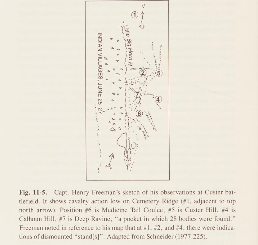
Henry B. Freeman's journal resides at Yale's Beinecke Rare Book and Manuscript Library. I link a copy of Freeman's sketch map made on the ground after Montana Column relieved Maj. Reno. Freeman travelled with Benteen's mission of 27th June, to the battleground and discovered Keeogh's dead. Freeman sketchThere is a fascinating and very well thought through assessment of the placement of battlefield markers in 1890, by Richard A. Fox in his 'Little Big Horn reexamined' which title he thankfully did not hyphenate. Don't you just hate authors who do? He dispels the upper SSL very well but is of course obsessed with 28 missing bodies. Fox understood his topic as though knee-deep in the matter and propositions through tediously rigorous complications of 'Capt. Sweet's Riddle' and its Rubik like difficulties. He missed a 'Yorick' trick with Carroll's 1886 discovery. At page 214 is a wonderful illustration of the terrain orientation complications presented at Little Bighorn which confound even those living there and viewing the ground daily from all aspects. Is the view northerly and up the hill towards the monument; or is it westerly from Calhoun Hill environs. Answer this my sons to be worthy of the coconuts. Fox made a lulu of an error with Freeman's sketch and it is in print and not going away. Here's his work and deduction at No. 1. His interpretation of Freeman's reference number one. Fox's understanding of the location of No. 1 is quite precisely WRONG. Surprisingly wrong beyond any rational point. It formed a part of the basis of his Cemetery Ridge theorising, which is all a Moon shot aimed at Mars. Complete supposition based on 'NO factual evidence'. Which is a remarkable disaster he has unfurled. |
|


 . Per Camp it is 2500ft away from there, and only 1700ft from Reno's retreat up.