|
|
Post by johnson1941 on Aug 20, 2023 10:57:56 GMT -6
I ts 1/2 mile difference - pretty big deal considering how much went on at Weir HILL, and how people like to mis-explain things that didn't actually happen at the Point.You should read the RCOI. Weir HILL was a well known fact/place, and it is referred to and its location and description is given...several times by several witnesses that ALL agree. See "POINT 7". "Weir POINT"? Not at all @rcoi - other then re: the Edgerly advance to the peaks - SEE "POINT 9", which BTW was 1/2 mile BELOW the highest point Weir HILL. No mistakes made (except by people forming the wrong opinions years later), in fact so many witnesses are surpringly in sync! Of course Camp confirmed it all too. The exact location and a lot of what went on there. Suggest you read this, which is a collection of numerous witnesses that were there... lbha.proboards.com/thread/5766/weir-hill-myth-cedarYou could also start with Herendeen... Q) If these lines represent General Custer’s trail, about how far would that be on this map?
A) I know that country and from the point we called Weir’s Hill, there is a sort of swale runs down and it is nice traveling to the creek that runs in there.
I was not over General Custer’s trail that season, but I was the next, but it was so obliterated that I don’t know exactly where it was.
Q) What is the character of the country towards “B”?
A) I claim that what is called Weir’s Hill is the highest point on the ridge in that vicinity.
Q) That circular mark is to indicate the position Major Reno took. How far from there can you see the country towards “B”?
A) To that highest point, Weir’s Hill, probably half a mile down.DeRudio. Q. Where was that?
A. It was on the highest point on the right bank of the creek just below where Dr. DeWolf was killed.
Q. Did you see the place generally known as the point where Capt. Weir went to?
A. Yes Sir I saw it .
Q. Was General Custer on that point?
A. No, on one nearer the river and the highest point on that side. Where I
saw General Custer the river comes right under the bluff. Benteen Q. How far down the river was the furthest point reached by any company under Major Reno?
A. About half a mile below that highest point. {THAT advance area is what became known as "Weir point"), not the highest point that was at least 3500' elev and 2500' further south (& just below where DeWolf was killed).If you have ANYthing specific saying otherwise, please post! Re the attached 1891 map showing the area... Camp "Bearings July 28. N End of Benteen's line to sharpshooters hill N 45 W. To
Edgerly Peak N 58 W. To Weir's hill N 68 W. To DeWolf marker N 64 W.
Sharpshooters hill is 1280 feet long and the course is N 44 W." |
|
|
|
Post by herosrest on Aug 20, 2023 12:56:17 GMT -6
A problem with all these named points is a fact of life with the battle, since none were named prior and many inferences, differing names and locations are and were applied. Comparing 1879 discussions such as those at Chicago, with Camp's work from 1908 and 32 and more years later, is problematic. For example, understanding Camp's idea of Weir and Edgerley hills or peaks is a blast, and one which remains difficult to fathom. Edgerley, seems to have dismounted the company and skirmished with the early responders to the probe towards Custer. The Black Elk accounts (Standing Bear) cover this. They put out enough gunfire to drive the band of 15 Indians including Standing Bear, under cover. But, it really ain't to clear whether this was Company D, or Godfrey's stand to retire by bounds. The testimony at Chicago, used props including maps, and developed a naming convention which can only be guessed at and pieced together. The transcript dialogues of question and answer, were only a part of the show as they sat pointing at and discussing maps. This is a cached image  found on the Bing from Hell nonsense microsoft quite rightly call a tool. Grab it while you can since they re-rank their rankings every 20 seconds and those are then used by ML, to plot colonising Mars and calorie counting green chocolates. I first ran into this on the CusterWest site and spent a long time wonering wtf.....  Have fun. They knew what they meant, at Chicago. That is each witness but there was no collective output but just a stream of personal observation offered within the context of the Inquiry. Camp made a lot of mistakes and corrected some but he certainly became confused with some of the stuff he looked into, such as north Medicine Tail Ck. That was a huge error in misunderstanding since everyone except Camp, knew NMTC was what is now Deep Coulee. That's an immense rising male chicken. |
|
|
|
Post by johnson1941 on Aug 20, 2023 13:44:46 GMT -6
Camp used Weir Hill cause Herendeen and Reno et. al. did at the RCOI. As Martin did quite specifically in his interview/correspondence.
The descriptions for the most part speak for themselves, especially once you know what they are referring to. As does Camps bearings and measurements - they are often quite specific too! As are the witnesses who were often there with him. As does the map they all used at the RCOI which corresponds pretty darn well to Weir Hill and edgerly peaks and the coulee etc. considering. See points 7, 8 & 9.
Please post SOMETHING concrete saying otherwise!!
No excuses are needed for the testimony re: this topic to make sense.
|
|
|
|
Post by johnson1941 on Aug 20, 2023 13:56:51 GMT -6
Except no one has posted anything to show that Weir Hill and Weir point are the same EXCEPT THEIR OPINIONS, or excuses why 1/2 dozen witnesses must have been wrong.
Facts! Witnesses! Anyone? SOMEONE?
And WHY IS THAT??? Cause Weir was on Weir HILL when he re-directed Edgerly - who made it to Edgelry Peaks IN ADVANCE of Weir!
Edgerly
@rcoi
"We moved out along the ridge to that point 7 {DeRudio sees GC} and then down the valley toward point 8 {Martin goes back from head of coulee}.
We went about 1-1/2 miles and then swung around...over to point 9 (edgerly marked map)...3/4 mile from "B""
w/Camp /Yates
"Edgerly says that Weir afterward to him that he had not received permission to go and that he had "not even asked for it.
After going a few hundred yards I swung off to the right with the troop and went into a little valley which must have been the one followed by Custer and his men, or nearly parallel to it, and moved right toward the great body of Indians whom we had already seen from the highest point.
{God I hope NO ONE is going to say Edgerly 1st went over a mile to Weir PEAKS/Point to see the 'great body of indians', and then came back to Reno and started over!! Clearly WP is NOT the “highest point” he is referring to!}
After we had gone a short distance down the valley Col. Weir, who had remained to our left on the bluff, saw a large
number of Indians coming toward us, and motioned for me to swing around with the troop to where he was, which I did. "
w/Camp
"When Edgerly turned down to right down the hollow, Weir standing on high point signaled that Indians were coming & he therefore turned back and circled over to left & crossed his track
& took high peak still in advance of Weir."
{since Edgerly “took the high peak in advance of Weir”, Weir was NOT at WP when directing Edgerly…he was on Weir HILL}
Godfrey
A. After the pack train came up the command mounted and moved down the river till the advance company came to that high point on the ridge below to that point indicated by the figure “9.” Three companies, I think, were up to that point.
Godfrey - who placed his reterat skirmish line 1/4 mile SOUTH of Weir HILL.
"Godfrey after passing the long ridge some distance, dismounted his men, forming a skirmish line at right angle to the river...CO K was guarding ridge in rear of Weir Hill about 1/4-1/2 mile south of Weir Hill".
Camp knew they were different - HE MEASURED BETWEEN THEM! HE TOOK BEARINGS TO THEM. Edgerly Peaks, Reno Peaks, Weir Peaks all same same in his ongoing referrals to them. Different from everyone's "Weir HILL"...just over 1/2 mile in fact.
|
|
|
|
Post by johnson1941 on Aug 20, 2023 14:26:00 GMT -6
And let's not forget Reno and Benteen (who marked Weir HILL with a G with DeRudio and Martin (who marked it pt 7, and Hare pt 5)) Reno RCOI Q . Do you remember about a guidon being placed at a point termed Captain Weir’s hill?
A. It was done.
...
Q. This guidon you speak of being planted as a rallying point for someone, where was it planted?
A. On the top of the highest hill. It was thought its fluttering might attract attention sooner than a horse.Reno Report "We had heard firing in that direction and knew it could only be Custer. I moved to the summit of the highest bluff, but seeing and hearing nothing sent Captain Weir with his company to open communications with him."
Benteen ROCI Q. How far down the river was the furthest point reached by any company under Major Reno?
A. About half a mile below that highest point.
Q. State what efforts, if any, that command made to inform General Custer or his command of your position by planting guidons or flags or anything of that kind.
A. The troops were by file on a line of river bluffs and, as I have stated, another company was formed at right angles on another ridge. I planted a guidon at the highest point that looked over that country. Some of the officers say that the battlefield was in sight, but I know positively that it was not, having gone over it two or three times sinceCamp also confirmed Benteen - that you couldn't see the battlefield from Weir HILL. Edgerly and numerous others confirm the farthest point of advance 1/2 mile below 'that highest point G/7/Weir's HILL was Edgerly Peaks and the crescent at Weir POINT. Martin confirms the ridge at highest Point 7 (where Custer saw village and martin & Benteen saw reno), vs the peaks at point 9 where they later advanced to. Attachments:
|
|
|
|
Post by johnson1941 on Aug 20, 2023 14:44:26 GMT -6
Again - your point isn't being backed up by - anything. Not witnesses anyway.
Just Ask DeRudio, Hereneen, Benteen. Reno, Martin, Curley.
Or tell me why they are all wrong, and can't judge distances.
A) To that highest point, Weir’s Hill, probably half a mile down.
Herendeen was there in '76, and the season after - he KNOWS what 1/2 mile is and he knew where Weir HILL and Reno's position were.
A. No, on one nearer the river and the highest point on that side. Where I
saw General Custer the river comes right under the bluff *.
DeRudio said specifically NOT the point Weir went to (the advance point 9), and there was no river near where the Peaks were, and the peaks are NOT '5-600 yards below Reno' but over a mile.
Interesting is that when you get this right, so much of the testimony and witness accounts make perfect sense - they all gel (with NO excuses).
|
|
|
|
Post by johnson1941 on Aug 20, 2023 14:48:31 GMT -6
Great map of Weir Point - but that's over a mile to the Reno Corral. And look how far that river is away from there! Nope - THAT IS NOT Weir HILL. try this...  Weir Hill is just over 1/2 mile from Reno, just down from the DeWolff marker, just where the river comes right up the bluffs, and 1/2 mile+ above Weir Peaks...where Custer 1st saw the village. Right adjacent Martin’s Ridge.  Attachments:
|
|
|
|
Post by johnson1941 on Aug 20, 2023 15:01:56 GMT -6
No. It says it the farthest point of advance, so its a 1/2 mile BELOW Weir's Hill, the peaks where the advance went to; that is now known as Weir Point. Again its 2500' from Weir's HILL to the southern peak at the Point. And 1700' feet from Weir HILL to the Reno retreat up (AKA 'just below where DeWolf got killed'). And you can ask Benteen. Benteen ROCI Q. How far down the river was the furthest point reached by any company under Major Reno?
A. About half a mile below that highest point. ("Point 7")Attachments:

|
|
|
|
Post by johnson1941 on Aug 20, 2023 15:33:05 GMT -6
Geesh ARE YOU READING POSTS? Did you actually READ the RCOI? "A. I know that country and from the point we called Weir’s Hill, there is a sort of swale runs down and it is nice traveling to the creek that runs in there."
"I claim that what is called Weir’s Hill is the highest point on the ridge in that vicinity."
"To that highest point, Weir’s Hill, probably half a mile down."
"Do you remember about a guidon being placed at a point termed Captain Weir’s hill?"
"I planted a guidon at the highest point" {where you COULD NOT see the battlefield}See how they all refer to the same place? NOT Weir POINT! Highest point = Weir HILL. More than 1/2doz people all explaining the same events at the same location - makes one want to go find it The highest point, aka Weir Hill, about 1/2 mile down from Reno, right where the river is against the bluff...it isn't that hard to find exactly where that is. ESPECIALLY with Camp's quite specific info, and Martin, and Benteen and Reno, and of course DeRudio, descriptions and statements. A. It was on the highest point on the right bank of the creek, just below where Dr. DeWolf was killed.
Q. Did you see the place generally known as the point where Captain Weir went to?
A. Yes, sir, I saw it. Q. Was General Custer on that point?
A. No, on one nearer the river and the highest point on that side.
Where I saw General Custer the river comes right under the bluff.
Q. About how far do you think it was from the point on the bluff occupied by Maj. Reno?
A. I think it could not have been more than 5 or 600 yards. It was a higher
point but lower down on the river.You would be very close - EXCEPT it seems Wagner made up 3411 after he saw some "3411" BM on a map from 1967, WITH A ROAD THROUGH IT!, and completely missed that about 300'(?) west right on the bluffs had been a 'high pinnacle' (see Goldin) - a point 3500' high in 1891 (and called higher in 1876 - it was after all "the highest point in that vicinity")...AKA Weir Hill, which had been called that at the RCOI and by Martin, Camp and his witnesses. So once again ANYthing from witnesses saying they were referring to the Point? ANYthing matching that location instead of what THEY CALLED IT - Weir HIll? I've been asking HR for that for months, and so far....nothing. Just opinions, and excuses why they must ALL be wrong. Something? Attachments:
|
|
|
|
Post by johnson1941 on Aug 20, 2023 15:49:13 GMT -6
Pretty sure it is that he went there and re-directed the Edgerly advance - as mentioned above. "Edgerly says that Weir afterward to him that he had not received permission to go and that he had "not even asked for it.After going a few hundred yards I swung off to the right with the troop and went into a little valley which must have been the one followed by Custer and his men, or nearly parallel to it, and moved right toward the great body of Indians whom we had already seen from the highest point.{I hope YOU ARE NOT going to say Edgerly went all the way to Weir Peaks/Point (pt 9) over a mile away, and then came back to Reno Hill and started over to go a few hundred yards then to the right!! Simple to see THAT WP is clealry NOT "the highest point" he referred to! (pt 7 is)} After we had gone a short distance down the valley Col. Weir, who had remained to our left on the bluff, saw a largenumber of Indians coming toward us, and motioned for me to swing around with the troop to where he was, which I did. "w/Camp "When Edgerly turned down to right down the hollow, Weir standing on high point signaled that Indians were coming & he therefore turned back and circled over to left & crossed his track
& took high peak still in advance of Weir."
Oh as a side note, Weir's Hill was also referred to as "Custer's Lookout". Gels with DeRudio testimony, right? Attachments:
|
|
|
|
Post by johnson1941 on Aug 20, 2023 17:42:16 GMT -6
You guys must have missed this: I learned something today. I am not even going to have a pity party. I GOT IT>>>>> I agree that you are right. Ah very sorry! - my miss! I thought HR had taught you something. He is totally confused and no help here  , though his notions do help me locate even more witnesses to confirm all this re:weir hill. So Thanks!! Nope WE are not confused. IT is NOT at Weir Point - this is Godfrey - and its confirmed by others - he protected the RETURN of the advance “south of Weir HILL” which means “south of Weir Hill” i.e. close to Reno i.e. “Near where stand was made”. Hare “A. Captain Weir and Captain French were the only ones who engaged the Indians till within 3 or 4 hundred yards of the final stand. Then Captain Godfrey engaged them.”We know from Hare - that was actually exactly at Reno's retreat up place. See attached. Attachments:

|
|
|
|
Post by herosrest on Aug 20, 2023 17:43:45 GMT -6
J41, I may be misreading your point that Benteen's 'G' relates to Weir, rather than being where Custer observed the valley from on climbing the bluffs and where for example, Kanipe rode back to Benteen while Martin continued on with Custer. Benteen knew of Custer's 'Last Look' because Martin told him. That was not presented during testimny at Chicago because..... I forget why, but that's not relevant. Weir may have been at Benteen's 'G' and it makes some sense since there were observations of activity downriver which some 'at the time' concluded was Custer's attack beginning. That was a while before Weir rode out and Edgerley followed, Before they sortied after Custer, a buch of scouts (pony stealers) had gone downriver along the bluffs and returned as Edgerley moved out after Weir. Benteen's 'G' is not Weir's Hill in any context related to the advance towards Custer. It is simply a location slightly downriver of Reno's Hill position, from where Custer made observations before advancing OVER the ridge which obsured all views of the east bank downriver. There is no better illustration of the Peak's complications than this aerial image, with a copyrite dating to 1975, which image I am certain dates far earlier. Hammer published in 1976. 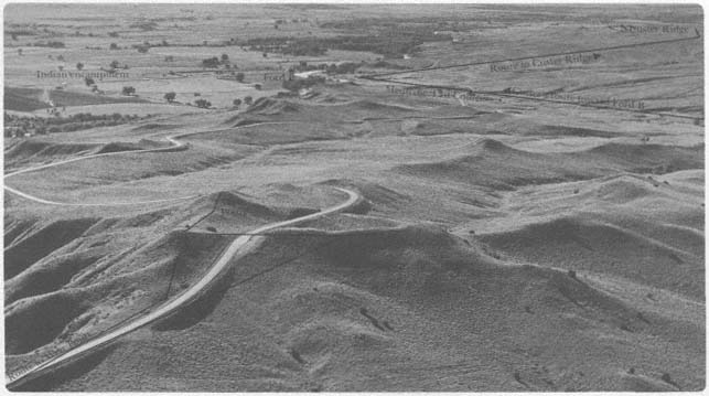 The majority of location information from those present is entirely round and hairy and since, as far aswe know today, little if any fighting took place to leave evidences on the ground, we are dealing with the recollections of participants, in amp's case, given between 1908 and 1925. Even descriptions of a ridge are bananas and believe it or not, Camp was of the opinion at one point (at least) Custer went to the edge of the bluffs where the river cuts right into them. This has nothing to do with facts or sources but rather what was going on inside Camp's tiny, overloaded, and confused mind, at a time when his principal influence was GODFREY, whose route to the battlefield is so far removed from reality as to destroy his credibity. Camp later began to question wtf Godfrey was up to. Camp's understanding evolved, his notes litter the entire period of his interest through 17-18 years and of course he was going back after every interview and insight to update them - wasn't he. Of course not. That's why they are so interesting as the work in progress. |
|
|
|
Post by johnson1941 on Aug 20, 2023 17:53:43 GMT -6
Rosebud, The map with the circles highlights the various descriptions used by the witnesses. Camp has very specific locators for weir Hill - which is shown in the attached 1891 in this post. camp explains it well. (he has altitude readings too, and obvious heights changed by 191x) via WMC, circa 1908-1910...
“It is 1700ft from Reno’s retreat up to Weir's Hill”
*"From Weir's Hill to the 2 highest peaks the course is directly northwest"
*"Highest Point - Edgerly Peaks - is almost direct NW from Benteen's horseshoe"
*"Weir Hill is 60 degrees west of North from same point"
*"Distance Weir Hill to 1st Edgerly Peak is 2500ft"
*"Bearings July 28. N End of Benteen's line to sharpshooters hill N 45 W.
*To Edgerly Peak N 58 W.
*To Weir's Hill N 68 W.
*To DeWolf marker N 64 W.
"Sharpshooters hill is 1280 feet long and the course is N 44 W."He did mark with a pencil “Weir Hill” one of his interview maps with Edgerly - while near the coulee, it does not match his specifics. He DID fix this in a later version. HR, Benteen's G refers qite sepcifically to 'the high point where Custer 1st saw the village'. It ALSO just happens to be "Weir"'s Hill per martin & pt 7 per DeRudio; the high point where "Weir" was while directing Edgerly. It was "the high/highest point in the vicinity" - makes sense they were there, as they must all past right by it as they traverese Martin's Ridge. Benteen confirmed with G where Martin (and DeRudio re:cheering/waving) says Custer saw the village 1st ("Weir Hill" "Point 7"). Martin with Camp plus various dozen or so other witnesses explain that and/or just what happened next - the turn down south coulee, horse pushers, stragglers, etc. etc. VERY busy place Weir Hill area. Martin w/Camp “Custer first halted on Weir‘s hill and took a 1ook at village…Here he turned column to the right and went down coulee to Dry Creek and turned to left and followed Dry Creek straight for village." AT RCOI Martin said this all was "about the same place" where he saw Reno action & Reno's Stand - Martin's Ridge. The scouts with horses moved up the bluffs near the same place got into the end of custer command and were shot at by them, its confirmed by those scouts. They would have had to come up much much later if they would run into Edgerly/advance. They didn’t. Stabbed was there. They saw Thompson. He saw them. Kanipe saw them on his way/their way back to benteen/pack. They were back there with their herd. Good thing so many of the witnesses agree. Attachments:
|
|
|
|
Post by herosrest on Aug 20, 2023 18:06:09 GMT -6
DeRudio and Martin are seperated by time. Unless you discount Varnum and accept WMRH's take on Custer having a coffee break while Reno gought the good fight in the valley for an hour.
Camp did not have a clue and as I have said, was impeded by Curtis's huge misunderstanding.
Reno fought the briefest of actions in the valley. The Officer,'s and troops on the bluffs were not chaining distance and topography and only had concern for the threats and routes of march. None expected the scrutiny which followed and could not have made notes for us today, if they had wanted to.
|
|
|
|
Post by johnson1941 on Aug 20, 2023 18:09:43 GMT -6
DeRudio stating he saw Custer where he did matches Herendeen's estimate of where Custer would be (Weir Hill) at that time - but not Varnum re:timing seeing the Gray horses in Cedar...he STATED it was about 1/4 mile below Reno at RCOI. Hmm...could Custer have lingered some while the command moved? (Martin says "10mins"). Martin says he saw Reno in action from 'the high point' on his return (after seeing C troopers in south coulee, and near Weir Hill), but not retreating. It is indeed a possible discrepancy. DeRudio's location/description however? Perfect. Heredeen's? Perfect. And they agree. Timing? UGH! "how near was General Custer to his battlefield when Major Reno left the timber with his command?"
"He ought to have been beyond Major Reno’s position on the hill, about half a mile. I should not think he was over two miles from the battlefield where he was found.
Q. Locate on the map about where that would be.
A. I don’t know how fast General Custer was traveling, and it would be a mere guess. A man with a good fast horse could have gone there before Major Reno left the timber.
Q. If these lines represent General Custer’s trail, about how far would that be on this map?
A. I know that country and from the point we called Weir’s Hill, there is a sort of swale runs down and it is nice traveling to the creek that runs in there..."This is interesting... A . It was back from the actual edge of the bluffs. The head and the rear of the column were both behind the edge of the bluffs in a sort of hollow and I just happened to catch sight of about the whole of the Gray Horse Company.
Q. State as near as you can how far that place was from you, not as you judged it then but as you became satisfied afterwards.
A. That is difficult to answer. I think they were a little farther down than where we struck the bluffs we came upon them and not quite so far down as the figure “2” in pencil on the map. They were probably three-fourths of a mile from where we were."
Seems this matches his Graham map fairly well. Just as a side note - South coulee is about a mile long, then another 9000' to get to the river. Attachments:
|
|


 Have fun.


 , though his notions do help me locate even more witnesses to confirm all this re:weir hill.


