|
|
Post by johnson1941 on Jul 16, 2023 15:55:25 GMT -6
What is Weir HILL ...from testimony at the RCOI... Herendeen, RCOI 1879 Q...how near was General Custer to his battlefield when Major Reno left the timber with his command?
A) It would be just a guess, depending on how fast he was traveling. He ought to have been beyond Major Reno’s position on the hill, about half a mile.
Q) If these lines represent General Custer’s trail, about how far would that be on this map?
A) I know that country and from the point we called Weir’s Hill, there is a sort of swale runs down and it is nice traveling to the creek that runs in there.
I was not over General Custer’s trail that season, but I was the next, but it was so obliterated that I don’t know exactly where it was.
Q) What is the character of the country towards “B”?
A) I claim that what is called Weir’s Hill is the highest point on the ridge in that vicinity.
Q) That circular mark is to indicate the position Major Reno took. How far from there can you see the country towards “B”?
A) To that highest point, Weir’s Hill, probably half a mile down.
DeRudio, RCOI 1879
A. I did not see any part of the column of General Custer. The only observation I made was while I was in the woods.
General Custer, Lieut. Cook and another man I could not recognize came to the highest point of the
bluff and waved their hats and made motions like they were cheering and pretty soon disappeared. I judge by that that probably his column was behind the bluff.
...
Q. Where was that?
A. It was on the highest point on the right bank of the creek just below where Dr. DeWolf was killed.

Q. Did you see the place generally known as the point where Capt. Weir went to?
A. Yes Sir I saw it .
Q. Was General Custer on that point?
A. No, on one nearer the river and the highest point on that side. Where I
saw General Custer the river comes right under the bluff . The bluff
comes in very narrow there hardly wide enough for a horse to stand on in
my opinion this map is not correct as to this line of bluffs.
Q. About how far do you think it was from the point on the bluff occupied by Maj. Reno?
A. I think it could not have been more than 5 or 600 yards. It was a higher
point but lower down on the river.
Q. Was it the highest point down the stream?
A. Yes sir and up stream too it was the highest point around there. I went on the top of it afterwards on the 27 with Capt. Benteen.
Hare, RCOI 1879
Does the point "2" afford a view of the Indian encampment below the plain?
A. No Sir, don't think it does.
Q. Does this point a little lower down?
A. You can see a part of it from there. I can’t tell anything about this point “2” from the map.
There is a point some distance below where Major Reno made his stand from which you can see the upper end of the village.
Wallace
"Soon after Captain Benteen came up while waiting for the pack train, most of the Indians left the bottom we came from, some of them occupying the points between us and where General Custer’s fight took place, the remainder went back into the village. There was a high hill which concealed the upper part of the village from us."
"Q. Was there any high point of land on the side of the river on which you were that was any nearer to the water than that which Major Reno took when he crossed over?
A. Yes, near the water.
Q. Where was that?
A. We had passed over it going to the point where the Indians first engaged Company D.
Q. "...With respect to the timber...was there any high point nearer the water than that which Major Reno took?
A. Yes, the one passed over AND the one D Company had at the point where it was attacked."
Martin, RCOI
A. ...then there was a kind of a big bend on the hill - he turned these hills and went on top of the ridge. All at once we looked on the bottom and saw the Indian village at the same time we could see only children end dogs and ponies around the village. No Indians at all - General Custer appeared to be glad to see the village in that shape and supposed the Indians were asleep is their teepees.
Q. Did the whole column go on to the ridge to look down?
A. No sir the whole command passed over it.
Q. Could you see the river from that place out there?
A. No sir the river was right at the foot of the bluff. We would see the village.
A. After General Custer saw the village with no Indians in it I suppose he
was glad and he pulled off his hat and gave a cheer and said "Courage
boys we will get them and as soon, as we get through we will go back to our station."
Q. Tell what direction you were then going.
A. We went more to the right from that ridge and went down to a ravine that
went to the river. At the same time General Custer passed that high place
on the ridge or a little below it he told his Adjutant to send an order back to Captain Benteen.
RCOI
Q. Can you point out on the map in what direction General Custer went after
he got to the point 7? {7=DeRudio saw GC}
A. General Custer struck to the right then struck a ravine and went down to the river.
We could not go over the bluffs because the bluffs were badlands.
Q. How far did you go till you got sent back?
A. It was about to the head of the ravine.
Q. Where do fix it if you can on the map. (the witness indicated the point by figure 8)
Q. How far was the point you left Custer from the place Reno made his stand?
A. I don't know I could not judge. It was 5-600 yards, or probably 3/4 mile.
Q. Where was that point from which you first saw Major Reno fighting? Was
it further up the stream then where he made the stand or at the same place?
A. About at the same place.
Q. That place from which you saw the village and children, dogs and ponies - was it the highest point down the river below where Major Reno made his stand?
A. Yes sir, the highest hill the very highest point around there.
Q. When you moved down afterwards did some of the troops go on that high hill?
A. No sir.
Q. How far was that high point from the head of the ravine you spoke of?
A. About 500 yards.
...
Q. When you left General Custer you could not see the river?
A. No sir it was on the other side of the hill - the hill was In front of us.
Attachments:
|
|
|
|
Post by johnson1941 on Jul 16, 2023 16:03:11 GMT -6
 Where is Weir HILL? (specific details on it location, besides just 'about half a mile down from Reno Corral’ and where "the river is right under the bluffs") via WMC, circa 1908-1910... “It is 1700ft from Reno’s retreat up to Weir's Hill” *"From Weir's Hill to the 2 highest peaks the course is directly northwest" *"Highest Point - Edgerly Peaks - is almost direct NW from Benteen's horseshoe" *"Weirs Hill is 60 degrees west of North from same point" *"Distance Weir Hill to 1st Edgerly Peak is 2500ft" *"Bearings July 28. N End of Benteen's line to sharpshooters hill N 45 W. *To Edgerly Peak N 58 W. *To Weir's Hill N 68 W. *To DeWolf marker N 64 W. "Sharpshooters hill is 1280 feet long and the course is N 44 W." ****************************************************************************** What can you see from Weir Hill? Camp (in 190x) "From this hill, can only see the Hunkpapa & Black feet lodges”
"from Weir Hill can see the Custodians house but not the monument nor any part of Custer battlefield"DeRudio Q. do you think General Custer from the position he occupied at the time you saw him could take in the whole situation of the Indian village?
A. Yes sir, I think he could take a pretty good view of our position at all events.
Q. Do you think he could see the village?
A . He could see a part of it. He could see the village as far as the conformation of the ground would permit him
...
Q. Now, if General Custer had a view of Major Reno’s command, did he not also have a view which indicated to him the extent of the village?
A. Part of the village he could see from that place and part he could not.
...
Q. Then General Custer saw Major Reno standing there with his skirmish line in front of that timber?
A. Yes, sir, he had a regular birds eye view of the whole thing.
Q. He saw the size of the village?
A. He saw part of it.
Hare There is a point some distance below where Major Reno made his stand from which you can see the upper end of the villageMartin "Then the General took me with him and we rode to the top of the hill, where we could see the village in the valley on the other side of the river. It was a big village, but we couldn't see it all from there, though we didn't know it then; but several hundred tepees were in plain sight."Benteen "...I planted a guidon at the highest point that looked over that country. Some of the officers say that the battlefield was in sight, but I know positively that it was not, having gone over it two or three times since"So Weir HILL, “the highest point”, is about a 1/2 mile below Reno Hill. And what about Weir Point? “Distance Weir Hill to 1st Edgerly Peak is 2500ft". Weir POINT is a mile below Reno Hill. |
|
|
|
Post by johnson1941 on Jul 16, 2023 16:04:39 GMT -6
What happened at Weir's HILL?
DeRudio
RCOI
"General Custer, Lieut. Cook and another man I could not recognize came to the highest point of the
bluff and waved their hats and made motions like they were cheering"
Martin
various
“Custer first halted on Weir‘s hill and took a look at village…"
"..says Custer's trail passed along where Reno retreated to. Then Custer halted command on the high ridge about 10 minutes, and officers looked at village through glasses.
"General Custer saw the village with no Indians in it I suppose be was glad and he pulled off his hat and gave a cheer"
"...here was then a discussion among the officers as to where the warriors might be and someone suggested that they might be buffalo hunting… Custer now made a speech to his men saying, “we will go down and make a crossing and capture the village. The whole command then pulled off their hats and cheered.”
Knipe
"Knipe says that Custer was trotting and galloping along with companies in column of twos, all 5 companies abreast, the men cheering and eager for a fight and that after the highest point on the bluffs was reached the men, through their eagerness, broke into something like disorder, as previously noted."
White Man Runs Him
W/Hugh Scott 1919
"Custer saw the camp from the highest point on the ridge to the right of the first intrenchment. He just saw Reno going down the valley but did not see him come back."
Goes Ahead
"Custer rode to the edge of the high bank and looked over to the place where Reno’s men were, as though planning the next move.
When they had arrived at about the point where Lieutenant Hodgson’s headstone was placed later, the three Crow scouts saw the soldiers dismounting in front of the Dakota camp and thought the enemy were “too many...."
Hairy Moccasin
"Custer yelled to us to stop, then told us to go to the high hill ahead (the high point just north of where Reno later entrenched).
From here we could see the village and could see Reno fighting."
"Custer's command as well as Bouyer and the 4 Crows saw Reno's fight in the valley. Then Custer and command turned down south coulee into Medicine Tail Coulee and went down toward river and out onto flat."
Curley/WMRH
w/HL Scott
Q. Where was Custer when you saw Reno come across?
A. Over the divide to the right of the first entrenchment. Custer saw the camp from the highest point on the ridge to the right of the first intrenchment.
w/Dustin 1938
"When we reached the ridge the soldiers kept marching on the east side of Reno Hill and going down to the west side of the ridge down a ravine, running northward."
At this point Custer and two other soldiers besides Bouyer and I rode over to a high point that overlooks the Little Big Horn Valley to see what was going on"
Thompson
Black Hill Trails
"We soon gained the top of the bluffs where a view of the surrounding country was obtained...
About a half mile further on we came in sight of the Indian village...When the companies came in sight of the village they gave the regular charging yell..."
Goldin
in a letter to Brady 1904
"As soon as this was discovered Custer rode over toward the river accompanied only by his orderly trumpeter, and
stopped for a moment on the top of a high pinnacle, where we saw him wave his hat, apparently in salutation to some one in the distance, and then come dashing back toward the head of the column.."
Daniel Newell of M Troop
"saw Custer's command on bluffs across river when Reno was fighting. He says at this time
Custer must have been 1/2 or 3/4 miles north of where Reno was corraled,
on edge of bluff, where he could see river. Says he was going fast when he saw."
|
|
|
|
Post by johnson1941 on Jul 16, 2023 16:06:53 GMT -6
What didn't happen on Weir Hill?
DeRudio
Q. Did you we the place generally known as the point where Capt. Weir went to?
A Yes Sir I saw it .
Q. Was General Custer on that point?
A. No, on one nearer the river and the highest point on that side. Where I
saw General Custer the river comes right under the bluff *.
Martin
RCOI
Q. When you moved down afterwards did some of the troops go on that high hill?
A. No sir.
Q, Did the whole column go on to the ridge to look down?
A. No sir the whole command passed over it.
And where does "the river come right under the bluff"?
At Reno Retreat, and at Weir Hill.
|
|
|
|
Post by johnson1941 on Jul 16, 2023 16:10:37 GMT -6
What happened next, after Custer waved from Weir HILL?
Martin
various
"...says whole column passed over the high ridge from which they could plainly see village and children and dogs in it. Martin says he was with Custer
after he passed the high ground and left him just as the command started down a ravine to get off the bluff, somewhat to the right of highest ground and about 1000
feet from it."
“Custer first halted on Weir‘s hill and took a 1ook at village…Here he turned column to the right and went down coulee to Dry Creek and turned to left and followed Dry Creek straight for village."
1908
"Then command "Attention" "Fours right" "Column right" "March" was given and command went forward down off the hill and then "Column left" and whole command passed down ravine toward dry creek."
"As soon as the command left this high point everybody passed out of sight from Reno's position and went down the hollow toward Dry Creek."
Curely
various
(re: Camp 1908)
On the first line of bluffs back from the river there are two high peaks marked “A” on the map, now called Reno peaks. For some distance south of these there is a high ridge running parallel with the river, but not so high as the peaks.
Custer’s command passed into the valley of a tributary of Reno Creek just behind this ridge and the peaks and went down it, going in a direction directly north and coming out into the bed of Reno Creek about a mile from its mouth at ford B"
"From the moment Custer's command commenced down this tributary of Reno Creek, it passed out of view of Reno's battalion, but Bouyer and his 4 scouts kept to the left of Custer, along the crest of the high ridge and peaks..."
"...By this time the last of the companies had disappeared over the crest of the hill, and thus Custer's command had vanished from his view by disappearing over the crest of a hill and down its west flank"
"Custer made a brief survey of the situation and turned and rode to his command. He did not ask Bouyer or me about the country - we rode following the creek as you know - we were all the time going away from the valley. We finally came out at the Creek - Medicine Tail Creek..."
Hairy Moccasin
"...Then Custer and command turned down south coulee into Medicine Tail Coulee and went down toward river and out onto flat. Two men were killed here.."
Goes Ahead
"...When they had arrived at about the point where Lieutenant Hodgson’s headstone was placed later, the three Crow scouts saw the soldiers dismounting in front of the Dakota camp and thought the enemy were “too many.”
Close to where Reno and Benteen later in the day were attacked by the Dakotas on the ridge of hills above the river, the three Crow scouts were left behind and Custer’s command went down the draw toward the lower ford on the run."
"Custer had told the Crow scouts to stay out of the fight and they went to the left along the ridge overlooking the river while he took his command to the right (Goes Ahead is sure Curley, the Crow scout, was not with him)"
"Went to bluff with Mitch Bouyer beyond point where Custer turned down coulee to right..."
"We saw Reno's battle and went back south along bluff and met Benteen's command. We three Crows did not see Custer after he turned down the coulee to right."
WMRH
His troops were moving forward below him. Custer turned around as he reached the top of the hill and waved his hat, and the soldiers at the bottom of the hill waved their hats and shouted. Custer then proceeded on up the ridge and his men followed. They were moving rapidly, and the scouts were forced to gallop their ponies sometimes to keep up with them. At a certain point on the ridge they turned to the right and rode down a coulee in a northern direction. The scouts took up a position on the high bluffs where we could look down into the Sioux camp. As we followed along on the high ground, Custer had come down Medicine Tail Creek and was moving toward the river.
Standing Bear, July 12, 1910
Was on bluffs (where Knipe saw Indians), and Custer went down coulee into Medicine Tail and crossed over to Custer ridge in full view of village.
Thompson
The Black Hills Trails
At this time a detail of five men from Company F was sent ahead to reconnoiter
and from this point I was gradually left behind in spite of all I could do to keep up with my company.
...By this time the last of the companies had dissappeared over the crest of the hill...
Kanipe
Right away whole command at about half past 2 pm went forward to highest point about 3/4 mile north of place of fortification and stopped there about 1/2 hour and then Indians rode up and fired and then whole pack of Indians came up and charged Reno about 3 pm
|
|
|
|
Post by johnson1941 on Jul 16, 2023 16:17:02 GMT -6
What about later re: Weir Hill & South Coulee?
Martin
"Inq. John Martin. Did Custer follow the bottom South Coulee all the way
and make turn into Medicine Tail or cut across the hill and save some of the
distance. He Dog seemed to think Custer cut across the hill.
No - Custer followed coulee all the way"
“Cooke wrote out the message to Benteen and I started back with it on the trail. I did not follow Dry Creek all way back to coulee running north and south but cut across the high ground. ...
"...I kept on up the north and south coulee and soon met a mounted man whom I recognized as one of C troop, but whose name I did not know."
“Met Boston Custer half way between medium coulee and Weir Hill."
"Soon after met Boston and met the two men. After this I heard a volley and looked back and saw Custer retreating back from the
river."
"Martin says that Benteen followed Custer's trail (Important): We marched on Gen. Custer's trail and when we got up this ridge from where I saw Maj. Reno fighting on the bottom we saw Maj. Reno's command and the Major himself, the men still retreating on the bluff."
Edgerly
@rcoi
"We moved out along the ridge to that point 7 {DeRudio sees GC} and then down the valley toward point 8 {Martin goes back from head of coulee}.
We went about 1-1/2 miles and then swung around...over to point 9 (edgerly marked map)..."
Edgerly 1881
After going a few hundred yeads I swung off to the right with the troop and went into a little valley
which must have been the one followed by Custer and his men, or nearly parallel to it,
and moved right toward the great body of Indians whom we had already seen from the highest point.
After we had gone a short distance down the valley Col. Weir, who had remained to our left on the bluff, saw a large
number of Indians coming toward us, and motioned for me to swing around with the troop to where he was, which I did. "
w/Camp
"When Edgerly turned down to right down the hollow, Weir standing on high point signaled that Indians were coming & he therefore turned back and circled over to left & crossed his track
& took high peak still in advance of Weir."
{Is this why the men there called the highest point Weir Hill? johnson1941. Yep…and the advance went another 1/2mile to another high point - Weir Peaks.}
Reno
RCOI
Q. Do you remember about a guidon being placed at a point termed Captain Weir’s hill?
A. It was done.
...
Q. This guidon you speak of being planted as a rallying point for someone, where was it planted?
A. On the top of the highest hill. It was thought its fluttering might attract attention sooner than a horse.
Reno Report
"We had heard firing in that direction and knew it could only be Custer. I moved to the summit of the highest bluff, but seeing and hearing nothing sent Captain Weir with his company to open communications with him."
Benteen ROCI
Q. How far down the river was the furthest point reached by any company under Major Reno?
A. About half a mile below that highest point.
Q. State what efforts, if any, that command made to inform General Custer or his command of your position by planting guidons or flags or anything of that kind.
A….I planted a guidon at the highest point that looked over that country. Some of the officers say that the battlefield was in sight, but I know positively that it was not, having gone over it two or three times since
Hairy Moccasin
"We went back on the trail up Medicine Tail and south coulees and along bluffs past Reno hill and on up nearly to Ford A, where we met the pack-train…"
French
in a letter
'Custer’s trail went over the saddle of the high ground'
Kanipe (w/Camp)
"I... asked to go with Benteen - "Yes come along with us. " I fell in behind and went along with
him. We went down to Dry Creek, on about the same route which I now believe
Custer followed, and then down Dry Creek nearly to the ford of the river.
"What trail followed on June 27 with Benteen. Struck straight across from
ravine Custer followed to Dry Creek."
|
|
|
|
Post by johnson1941 on Jul 16, 2023 16:36:35 GMT -6
What else happened in that area?
Godfrey
"Indians were coming in swarming along the ridge which the troops had just left (there were no indians in the coulee to the east Godfrey says...by this I mean the coulee down which Custer marched)"
“ I had gone but a short distance when Captain French’s company came down the hill passing to the rear very rapidly and soon after Lieutenant Edgerly with D Company came down the hill quite rapidly. The Indians followed them to the crest of the hill and began a very heavy fire on them. As soon as I saw the Indians I dismounted my company and threw it out as skirmishers, and as soon as Lieutenant Edgerly and his company passed I commenced firing on the Indians and drove them back behind the hill, and they took position there behind the hill.”
"Godfrey after passing the long ridge some distance, dismounted his men, forming a skirmish line at right angle to the river...CO K was guarding ridge in rear of Weir Hill about 1/4-1/2 mile south of Weir Hill"...
Hare
“A. Captain Weir and Captain French were the only ones who engaged the Indians till within 3 or 4 hundred yards of the final stand. Then Captain Godfrey engaged them.”
Wallace
"Soon after Captain Benteen came up while waiting for the pack train, most of the Indians left the bottom we came from, some of them occupying the points between us and where General Custer’s fight took place, the remainder went back into the village. There was a high hill which concealed the upper part of the village from us
Knipe
"..says when column went down in direction of Custer, he went with Co. H and saw Thompson's horse standing near head of hollow down which Custer marched"
Hairy Moccasin
"As we came along the bluffs a short distance north of the DeWolf marker we met a dismounted soldier who had come up the bluffs and he went along with us until we met the pack train"
Thompson
'After the dissappearance of Custer and his men...While mediating on the combinations...I saw a small party of Indians...driving mules and ponies...I saw something familiar in their appearance..
Soldier
Arikara Narrative
"We came upon a white soldier whose horse had given out, and he was kicking the horse and striking him with his fist and saying “Me go Custer. Me go Custer.”
...
As we went up a little dip we looked over and saw the valley full of Sioux tepees...
...
I soon came across a second soldier whose horse was down, overcome by heat, and he could not get him up and was swearing and calling him a son of a bitch and kicking him. Just after this I saw Ree scouts who had captured horses come up the ridge and Strikes Two said: “Leader, I will give you this spotted horse that is leading the herd.”
Where they came up the river ran right along the foot of the bluff."
Strikes 2
re:Camp 1910
Did those who captured ponies see anything of Custer and the five companies
when they ascended the bluffs or before? Yes passed near him and were
shot at by a few of the soldiers. They must therefore have come up just
after Knipe left.
Aug. 7, 1910.
How long before battle began did Rees
capture Sioux horses? Quite a while.
How far was it from place ran them up the bluffs to Reno corral?
Just about where Reno retreated up says Strikes Two.
John McGuire
Camp interview
"Did pack train start toward Custer when Godfrey, Benteen, and others moved down that way? Yes, went to top of ridge where could see Weir out ahead."
|
|
|
|
Post by johnson1941 on Jul 17, 2023 12:44:50 GMT -6
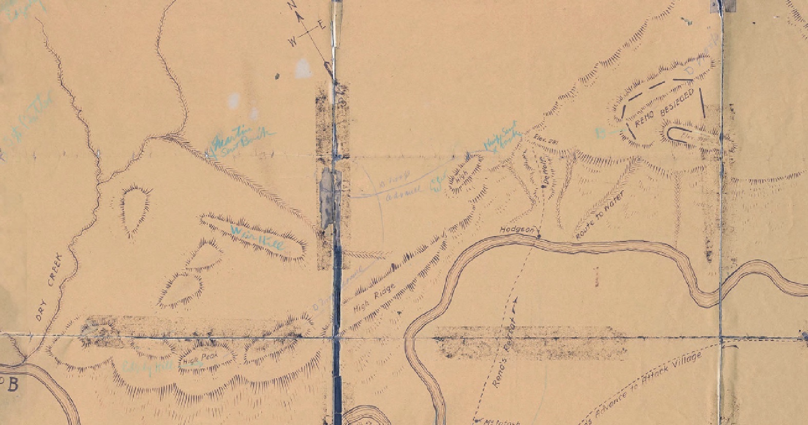
 Discrepancies? Scouts WMRH vs WMRH (w/Curtis MAYBE) Curley vs Curley? 1886 Gall & Godfrey troop route notion further east The height of Weir HILL in 1891 was 3500'. It was "the highest point in that vicinity" in 1876-1879....MaGuire at the RCOI had the Hill 60' higher (@150'AGL) than Reno's spot (@90'AGL). Camp by 1910 had the Weir Peaks at higher elevations (+/-60'). That "high pinnacle" is no longer there, not at nearly that height at least. There is a road over the saddle between its location and SSR. The swale that runs down from it provided "nice traveling to the creek" in 1876-1879, not sure if that is still the case. A Camp-surveyed map marked "Interview with Edgerly", showing D troop's route, Martin's "ELEVation", north-South coulee, Kanipe and Martin being sent back, a Weir Hill - which doesn't line up with his described location/bearings, and Edgerly Hill and peaks; {also shows Hodgson - but Hodgson's marker as referred to by the scouts was originally located up just north of Reno Corral}. Camp superseded this map with a better one to more accurately show feature locations, including Weir Hill; this is where Custer 1st viewed the village - near Reno retreat up/DeWolff, 1/2Mile from Reno Corral.  Benteen is all over re: highest points and distances, at various times (rcoi vs wife letters). He did confirm views and distance. And confirmed his G with Martin and DeRudio after the battle. Attachments:
|
|
|
|
Post by herosrest on Jul 18, 2023 13:06:04 GMT -6
|
|
|
|
Post by johnson1941 on Aug 18, 2023 4:47:04 GMT -6
Even Curtis knew of Weir Hill...  On the Custer outlook Summary Edward S. Curtis (second from right) and four Apsaroke men, seated in half circle, their horses behind them. Names Curtis, Edward S., 1868-1952, photographer huffman,1916 “Godfrey and Camp looking down hill overlooking DeWolf marker and Pym water route”  Attachments:
|
|