|
|
Post by ephriam on Feb 28, 2022 8:53:52 GMT -6
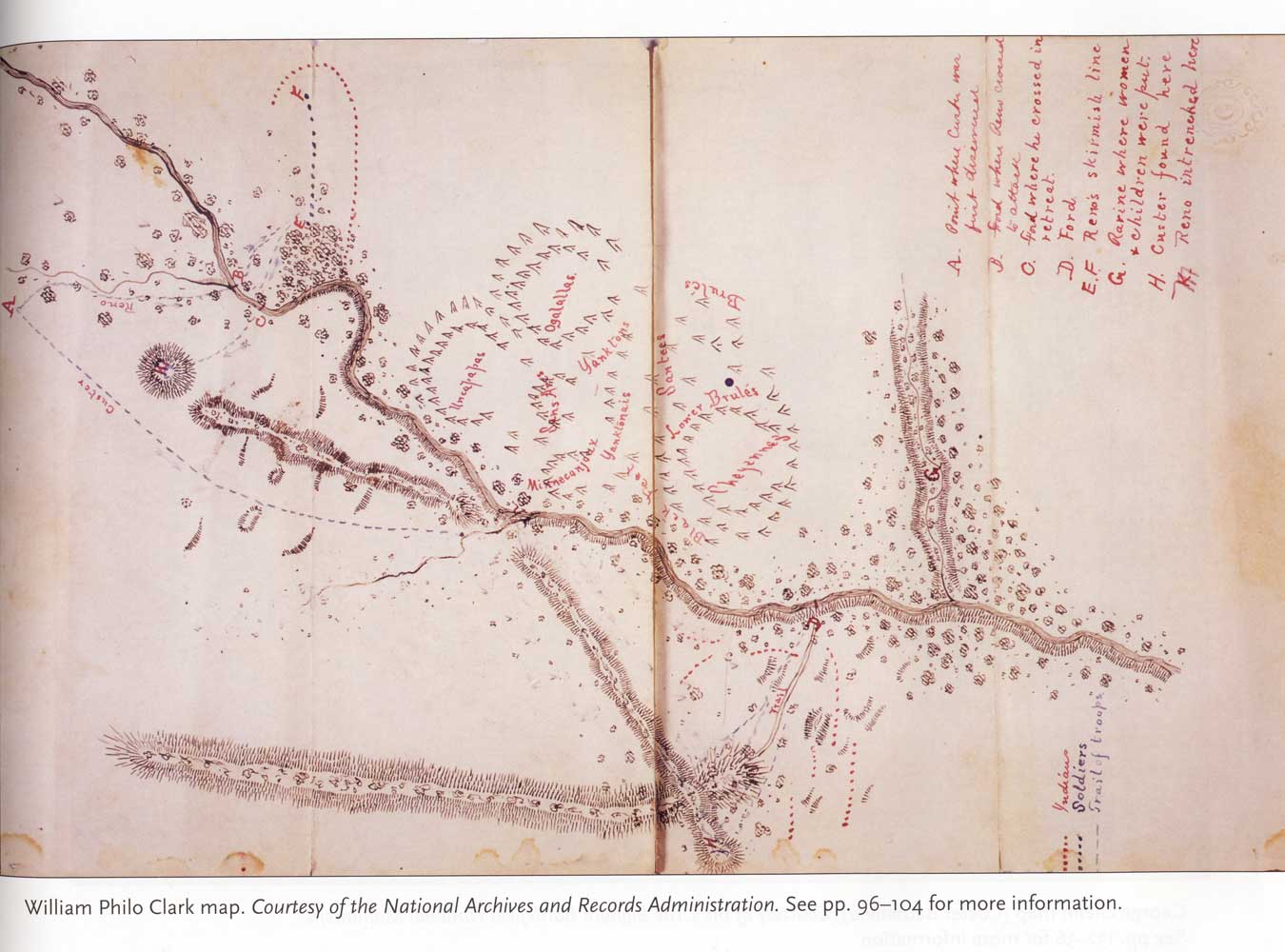
Many native maps of the Little Bighorn battlefield depict the Indian village arranged in circles, such as this one drawn by Lieut. William P. Clark in 1877 after an interview with a battle participant. (See Michael Donahue’s excellent book Drawing Battle Lines to review other maps.) Author Greg Michno speculated in his book, Lakota Noon, that references to camp circles in Indian accounts however may have been “just a convenient word, analogous to a gathering of lodges set in no particular configuration…” Michno concluded “there was no necessity for setting up camps in large circles on the Little Bighorn.” However, I disagree. This question of how the Indian camp was arranged at the Little Bighorn is more than just an academic detail. The presence of the formal camp circle is evidence of a particular form of native government in effect on the day that the 7th Cavalry arrived. This is a critical detail for understanding how native leaders responded and made decisions when suddenly confronted by an attacking force. In 19th century Lakota culture, every band or tiyospaye was autonomous, with its own leadership who made important decisions for their immediate community. But when multiple bands came together for brief periods, such as for the annual sun dance ceremonies, social conflict was avoided by naming several temporary leaders from the different bands who served together for this brief period to decide about camp movements, etc. This temporary leadership council met in a special large lodge set up just for this purpose in the center of the camp circle so that the discussions and consensus building process could be visible to all. During this period, the individual bands temporarily gave up their individual autonomy for the good of the larger community. Once the gathering was over, the decision-making authority returned to the individual bands as they scattered to travel and hunt. Several clues suggest that the temporary tribal circle form of government was still in effect on June 25, 1876. In addition to the Indian maps showing tribal circles, notice that Kill Eagle specifically mentions a large council tent for the Hunkpapa camp. The headman Red Horse also mentioned a large council tent in the Minneconjou camp. He was about a mile away from the village on the morning of June 25 when the approaching cavalry was spotted and he raced back. “…when I got there [the village], I was sent for at once to come to the council lodge. I found many of the council men already there when I arrived. We had no time to consult one another as to what action we should take.” This form of temporary leadership structure for the Lakota worked well when decisions could be reached after much deliberation, but during an emergency, this was not an effective process for making quick decisions. Red Horse noted that the Minneconjou camp council quickly agreed to simply follow their traditional defensive actions: “We gave directions immediately for every Indian to take his horse and arms; for the women and children to mount their horses and get out of the way, and for the young men to go and meet the troops.”  |
|
|
|
Post by noggy on Mar 2, 2022 9:02:09 GMT -6
I really like the Clark map, for some reason. Nothing to add, so I'll just rant a little about nothing:
It seems to be concensus among many that the Natives almost never worked together, just like how they "always ran". Neither claim is correct, and at best is a misunderstanding of both culture/the big picture (let's not forget we are NOT talking about a homogeneous group of peoples) and battle tactics. History shows countless examples of how in times of grave danger, Native Americans could lay their love for independence aside in order to stand against extraordinary dangers. White people/new countres being just such. Such type of co-op demands a certain chain of command or "leader(s)". There were several confederations in the East. In the South, the Seminoles in Florida together with members of other tribes and freed slaves came together and fought three wars against the US. Cochise united several small bands of Apaches after the Bascom Affair and later disgusting murder of Mangas Colorados, fighting the US (and Mexico as always) for about ten years straight. The Comanches consisted of several bands who could join forces, and be reinforced with warriors from other tribes. The Southern Cheyenne, Arapaho and Kiowa would join up under a "joint command" too to fight the Americans. Red Cloud, anyone? Etc etc.
One of Sitting Bull's rallying cries during the early Spring and Summer of 1876, when trying to get NAs to follow him/leave the reservations was on of "United we stand, divided we fall". Isolated camps were easy targets, as shown earlier that year at Powder River and on occations like Washita. I know it was common practice, and perhaps some cultural things I don't understand played inn too, to usually camp at some distance from each other when travelling with allied bands. But these weren't normal circumstances. During the Summer of 76, they pretty much knew it was do or die for their existence and entire way of life. So a "War cabiet" consisting of the big boys makes sense, it was done during Red Cloud's war too, so why not now? Keeping the camps in tight formation is also just tactically prudent, they new the soldiers were after them.
All the best,
Noggy
|
|
|
|
Post by crzhrs on Mar 2, 2022 15:04:54 GMT -6
The LBH Camp was due to break up even if the 7th didn't find them.
A camp the size of the one at the LBH was excessively large. There were thousands of horses eating up the grass in addition to defecating/urinating. Sanitation including human waste would have made it impossible to stay together much longer.
In addition hunters had to roam further afield for game.
After the battle the camp broke up with various clans/groups staying together but the big camp was over and once again the Indians traveled in smaller groups.
It would be weeks if not months before the military was able to regroup, re-outfit and have enough manpower to go after the Indians.
|
|
|
|
Post by backwater on Mar 3, 2022 22:00:33 GMT -6
|
|
|
|
Post by backwater on Mar 3, 2022 22:04:21 GMT -6
this has council tipi Attachments:
|
|
|
|
Post by herosrest on Mar 5, 2022 13:24:13 GMT -6
General Charles Roe's narrative of the battle, dated March, 1910, published in Tom O'Neil's Arrow and Trooper booklet, 1997, titled The Battles of the Little Big Horn.
Quote: 'The village had been left standing, as regards tepee poles, but the skins had been stripped off. It was laid out in the form of an enormous circle, and adjoining it, a three-sided rectangle. By actual measurement made by an engineer sergeant, from the circle on one side to the far side of the rectangle on the other side was three miles. Around the main tepees were wickyups made of willows used as temporary shelter by warriors....'
Going to memory, I believe it is 'The Terry Diary' he had the number of marks left on the ground by absent tipis counted as 1800 and some further 400 temporary structures. There were two somewhat mingled camps as that of the 25th June moved a little downriver during the later afternoon with the five companies destroyed and balance of 7th Cavalry coraled on the bluffs.
It's all a bit of a pig's ear of organisation and relocation and of interest also is the little known of triangular camp - if Roe's recollection is reliable. I give it some weight since he had scouted the valley two months before 7th Cavalry fought and saw the old camp ground of previous years on the mouth of LodgeGrass. I suspect this played some part in Terry's planning to expect that to be where the roamers would be. In fact they had intended to be at LodgeGrass but the elders decided to move downriver instead from the pre_battle camp site located on the east bank from Benteen in the valley to Ford A.
The move was madeon the 24th I believe and confounded Custer's scouting that evening.
Thete is a minor note from an interview of a Minnieconjou present given with a sketch map, showing and telling how that tribe camped in bands (of their chiefs) I assume; in a straight line along the river. Walter Campbell OU collection. This is somewhat consistent with Roe's triangle but makes sense on Minnieconjou ford on the 25th date, with that lay of the land and river.
I can only imagine the valley camps as being ordered chaos of temporary nature and comings and goings and reactions to the attack.
Regards
|
|


