|
|
Post by fred on Feb 2, 2014 12:23:04 GMT -6
"Alfakilo,"
That is a beautiful job... a great picture of Deep Ravine. What a difference!
Did you ever fly photo-recon missions?
Best wishes,
Fred.
|
|
|
|
Post by alfakilo on Feb 2, 2014 12:32:06 GMT -6
"Alfakilo," That is a beautiful job... a great picture of Deep Ravine. What a difference! Did you ever fly photo-recon missions? Best wishes, Fred. I've been very happy with Paint Shop...it usually makes any picture more vibrant. The recce guys were in dedicated units and did little else besides take pictures. I flew my missions in a unit that was pretty much nothing but close air support, both day and night. |
|
|
|
Post by Margaret on Feb 2, 2014 13:31:24 GMT -6
I have a question if anyone can answer please, regarding that photo of the south skirmish line... can I see the Crow's Nest along the ridge in the background... if so, which hill is it? that high peak left of centre would it be...?
alfakilo,
I like the way you have altered Fred's photo, it's like retouching, however it appears more like a black and white photo now, as the yellow flowers or leaves on the tree above Fred's head appear white in your version.... so pro's and con's with that I think... but it appears a clearer image...
..fine looking man, young Mr Wagner... reminds me a bit of Elvis, in his day...
|
|
Deleted
Deleted Member
Posts: 0
|
Post by Deleted on Feb 2, 2014 14:25:12 GMT -6
Margaret,
I think the Crow's Nest would be much farther to the left (as the picture is viewed) and certainly out of the picture. Alfakilo is much better at locations than I. Perhaps he'll stop by!
I'm guessing there's no "standard" for monitor calibration and that could account for color variations from one viewer to another. Well, maybe!
Best,
Chris
|
|
|
|
Post by Margaret on Feb 2, 2014 15:44:25 GMT -6
..thank you feral... yes I should have known really, I've been there a few times.... well to the left as you say... actually, I think I've found a great photo of it on another thread in this gallery, originally posted by WY Man.... I do love this shot... and I think it shows the Crow's Nest... perhaps someone could confirm that for me...which one is it? also is Varnum's Lookout visible in this or not...? actually I don't think it is now... oh darn it I'm getting so confused.... that doesn't look like the divide to me.... 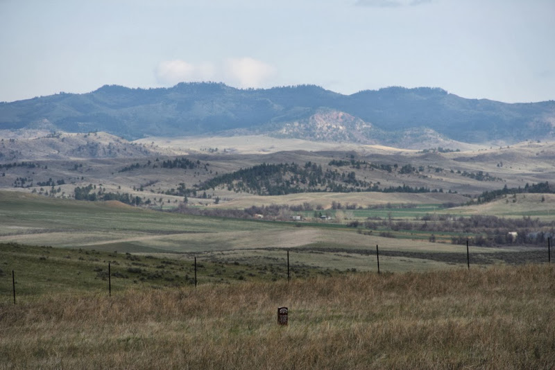 |
|
|
|
Post by fred on Feb 2, 2014 16:46:46 GMT -6
oh darn it I'm getting so confused.... that doesn't look like the divide to me.... Margaret, I cannot place that shot, but it doesn't look like the Crow's Nest to me... too close. There is a red granite Indian marker near the foreground, leading me to believe it is the Reno-Benteen field and I think it may be a southwestern perspective. Could those be the Big Horn Mountains? That straight line in the picture looks like it may be the Interstate highway.... Cannot be sure, however. Best wishes, Fred. |
|
|
|
Post by Mike Powell on Feb 2, 2014 17:39:27 GMT -6
I think those have to be the Wolf Mountains and I believe the road bisecting the green field in the middle distance is Reno Creek Road. I can't immediately tell just what the direction of view is but I'd agree the
Crow Nest is probably to the left.
I've got a couple of pic's of the CN in the distance from the Davis Creek side. I'll post them at halftime.
|
|
|
|
Post by alfakilo on Feb 2, 2014 19:12:56 GMT -6
oh darn it I'm getting so confused.... that doesn't look like the divide to me.... Margaret, I cannot place that shot, but it doesn't look like the Crow's Nest to me... too close. There is a red granite Indian marker near the foreground, leading me to believe it is the Reno-Benteen field and I think it may be a southwestern perspective. Could those be the Big Horn Mountains? That straight line in the picture looks like it may be the Interstate highway.... Cannot be sure, however. Best wishes, Fred. It does look close but I think that is due to the camera perspective ("foreshortening", I think it is called). From what I've read, the CN is just slightly to the left of center, right below those puffy white clouds. |
|
|
|
Post by Margaret on Feb 3, 2014 5:40:11 GMT -6
..o.k... thanks for your help here everyone... I think I have some interesting news regarding this photo,... I hope so... goodness, why am I so obsessed with all this... ...if you look again at the photo above taken by WY Man... and look below the high ridge and just to the right of centre, you will see two large humpy rough looking hills - they are below the high ridge behind... the one on the left much bigger than the one on the right.... just below the smaller one on the right, you will see a very small patch of dark green trees that then ascend a little to the right becoming very sparse, to go off the picture.... this I think is the South Fork Reno Creek... and the sloping grassy plain below and just to the left of these two humpy hills is where the Indian village was camped, or centred, on June 16/17th.... ...The Crow's Nest, divide and Benteen's first line of bluffs would be well off to the left of the photo, and would need the same size image taken again moved leftwards to get them in... shame about that... however, I have posted below a photo - of a photo - that I originally took in 1998 and covers a wider angle than the one above but incorporates the same view.... ...if you look at my photo below, and where I have marked North Fork Reno Creek... immediately under the capital R of Reno, is the same ridgeline, plus I can see those two humpy hills below, and look for the prominent clumps of trees in the centre on a hill, with a kind of circular border of bushes all around them ... that you can also see much better in WY Man's image...right in the middle of his shot... you can also see on my picture just how far to the left the Crow's Nest is of this point... ...WY Man must have taken his from standing on the hill above the North Fork Reno Creek which is not in shot below, just beyond the posts and I think just down from the darker green grassy ridge with some small bushes that you can see.... the flattish field like area beyond this leads onwards to the right to an area that we know as 'The Flat'.... which then leads to the confluence of Reno and it's North Fork.... the main Reno Creek swirls around the wooded hill in the centre to some buildings you can see there - centre shot - nestled along it and below that hill... ...the headstone in the foreground is for the Indian 'Dog's Backbone' shot probably by members of 'H' Troop who were at this end of Reno Hill... ..I hope that's clear,... and I hope too that I've got it right....I think so....what do you think...? here's my photo from 1998...it's rather poor quality in comparison... can't do much about that.. best ignore all my arrows pointing every which way....this thing perplexes me and drives me to distraction.... 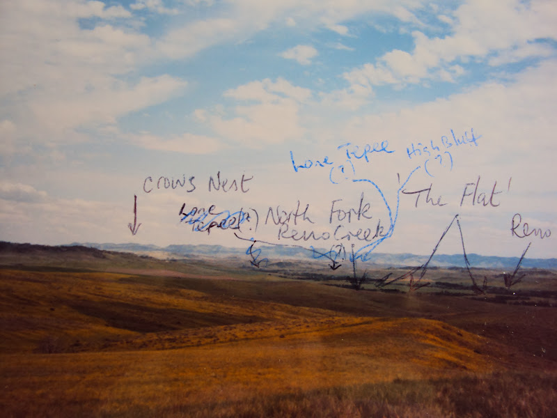 |
|
|
|
Post by fred on Feb 3, 2014 7:38:23 GMT -6
Margaret,
I think you and "alfakilo" are absolutely correct and I was wrong. I am pretty sure I have a similar picture and we had identified the Crow's Nest in that one. Give me a little time and I will see if I can dig it up.
Also, do not get hung up on the location of the lone tepee. The old, traditional site is below some bluffs, some 4 1/2 miles east of the river, but I reject that site. Latter day evidence-- such as it is-- along with a very careful examination of participant accounts, have proven to me the location is only some 1.7 miles east of the LBH River. And quite frankly, I believe the physical evidence-- while, as always, circumstantial-- is overwhelming.
Best wishes,
Fred.
|
|
|
|
Post by Mike Powell on Feb 3, 2014 10:13:20 GMT -6
Margaret, If you return to Wyoming Man's photo of Dog's Back Bone marker, immediately below is a second photo of that marker, oriented more easterly than the first. In this second photo the Wolf Mountains are visible much as they are in your annotated photo. Here is a picture from east of the Divide on Davis Creek. My son and I, following the directions of our guide and in this instance photographer, Dennis Fox, are pointing to the Crow Nest. i believe this pic was taken at the likely site of the Second Halt. it's right between our fingers. 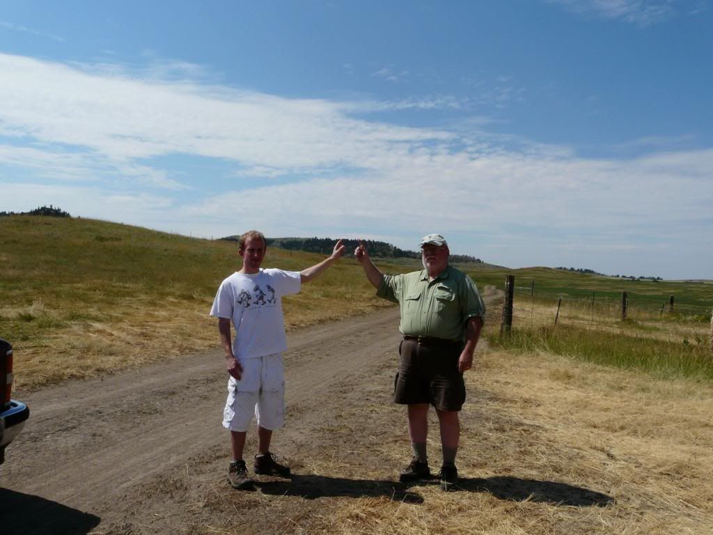 |
|
|
|
Post by Margaret on Feb 3, 2014 17:31:37 GMT -6
Mike...
thanks so much for posting that photo...you are in the very place I always wanted to go, but didn't make it... I'm surprised to see the ground sloping the way it does and it's quite a gradient going up to the divide there.. it seems so to me anyway...I suppose I thought it would be much flatter...great to have your Son involved too..
..additionally...how far would you say the 'Nest' is from where you are standing.... it's got to be over a mile isn't it..? less than 3? just puzzled... thanks..
..yes. I've looked back on the photo on the other thread... it does indeed cover more of that ridge..shame a low hill is in the way in the foreground.... I wish he had taken some more close ups of the area..they are such good shots..
|
|
|
|
Post by Margaret on Feb 3, 2014 17:44:04 GMT -6
Fred,
...that's ok... I wrote on that photo back in 1998, when everyone, and I expect you too... presumed the Lone Tipi to be around the South Fork area....I was rather desperate in trying to find it... I think a lot of people still do... I know you now refer to that as the Eastern tipi... and the one you believe is the real one at 1.7 miles from the river.. due I think also to someone finding some ancient buffalo hide strips nearby... and I suspect your timeline supports it there...
so yes,, hung up in 1998.... but less so today... looking forward very much to seeing any photos you may have, in due course....
...I should add that, I no longer accept John Gray's assertion that it was situated at the South Fork, and I don't like the way he interpreted testimonies to support it... I did think though that it was a bit closer than 1.7 miles as you have... Gerard said something different I think - 1 - 1-1/4 miles....I have another photo from that time where I've written 'Gerard's Knoll' which I have placed near the confluence of Reno Creek's...as Gerard said.... and presumed the tipi was down near that...
obviously still hung up Fred....
|
|


