|
|
Post by herosrest on Sept 5, 2023 9:17:59 GMT -6
|
|
|
|
Post by herosrest on Sept 5, 2023 9:24:52 GMT -6
Please remember that there was a gap and no-one minding it!  The counter point link |
|
|
|
Post by herosrest on Sept 6, 2023 12:39:43 GMT -6
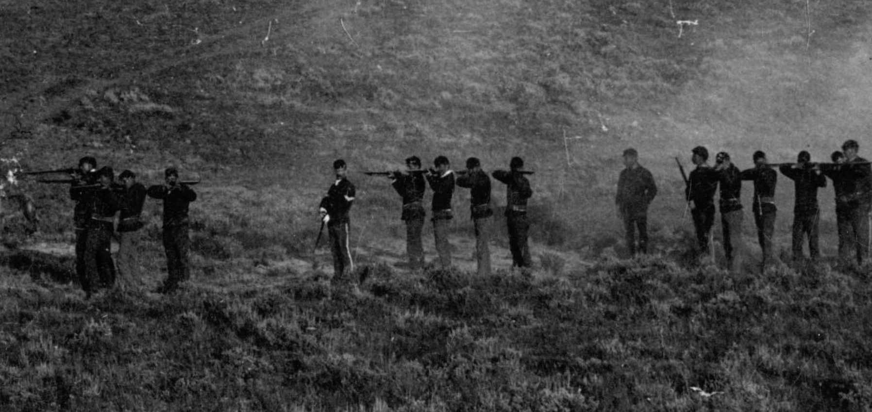
The posit locates a Gall indicated and Barry photographed cavalry fighting position, to the east side of modern Battle Ridge and facing east. The location was noticed considerably long ago (by me) in comparisons of the Barry image with the broader surrounding horizon backgrounds. Proving the comparison clinically will alter erstwhile theoretical work stemming from the the 1980's in publications of work and supposition that a primary interest of the 7th Cavalry's attack at Little Bighorn was hostage taking, perhaps in desperation, which failed at the first hurdle of crossing distant fords far below the battle's culmination above the river on a deep coulee which became a ravine. This work parallels, if not mirroring that undertaken by a trinity of battle enthusiasts for the book, 'Where Custer Fell'. Later technology offers the possibility of far better and quicker comparison data from the ground utilising advanced airborn imaging to survey the terrain, and importantly, develop refined and broad viewsheds to help evolve the poor and unmilitary mindsets undertaking earlier projects. My interest now is for a command drone able to operate over the terrain after the 4,450 mile flight from England. Return is not an issue since datalinks render the hardware expendable. The hope is to improve considerably on the level of detail here youtu.be/NECfqmY4kC4 and match the Barry fighting line to markers on the east flank of Battle Ridge, rather than the bland cursory view of the past that it is all to do with views west into the valley of the Little Horn. A 4,500 mile drone deployment..... hmmmmm............ |
|
|
|
Post by herosrest on Sept 7, 2023 4:01:00 GMT -6
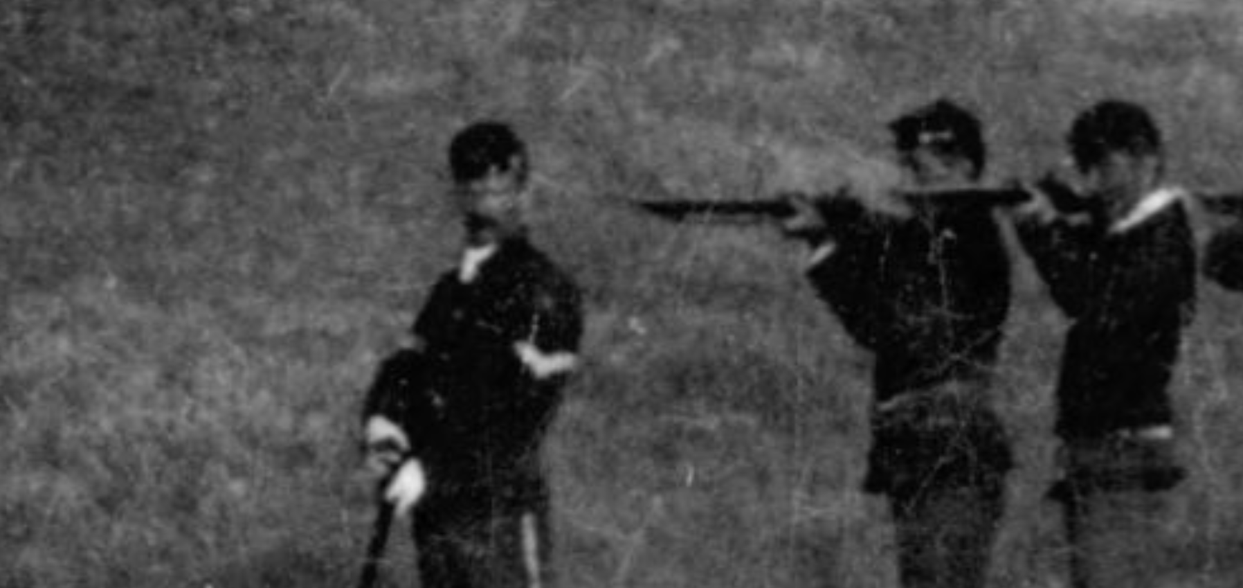
Central to this tenet is Gall, and his 10th anniversary of the hatchet job. At that gathering, he gave a number of interviews, at least three including Godfrey, Barry and the Pioneer Press. The latter is tediously interesting for a number of reasons but and however, across the years, Gall has been wafted about the battlefield by a succesion of authors who place him, there, here and any everywhere (Spirit) with his bloody axe. Let's see what there is to be seen. Remember that someone has just wiped out your family in the valley and revenge is your duty. |
|
|
|
Post by johnson1941 on Sept 7, 2023 5:04:47 GMT -6
Weird...
account 2..
"Did you fight Reno?"
"No; I only fought the white men soldiers down this way."
"Then you know nothing of what happened at the upper end of the village?"
"No, I was down among the Cheyennes looking after horses when the first attack was made on our village."
account 1
"Reno swept down so rapidly on the upper end that the Indians were forced to fight. Sitting Bull and I were at the point where Reno attacked. Sitting Bull was big medicine. The women and children were hastily moved down stream where the Cheyennes were camped."
Important as Astonisher says he was fighting Reno, and would miss intro moves by Custer...not sure if that is true.
And this is your subject here(?)
"it would appear that Calhoun's men died fighting as skirmishers, while Keogh rallied his company, which was all killed in a bunch."
...
"Therefore, Custer personally and those with him were probably the very first ones to fall in the day, and Calhoun and Keogh, taken on both flanks, jammed in between two galling fires and numerous cross fires, and with all possible avenues of escape cut off, had nothing else to do but fight it out in line until the last trooper had fallen in his tracks.
Very cool - keep at it!
|
|
|
|
Post by johnson1941 on Sept 7, 2023 5:06:05 GMT -6
Can you post that Barry photo from post 1?
|
|
|
|
Post by herosrest on Sept 7, 2023 9:12:23 GMT -6
 Joomed copy from site app, and page image from app. As you zoom in, you gain detail in zoom. If that makes sense. If you wanted the highest resolution available from the site app, then it's save and stitch them together. Were you having trouble with the link? |
|
|
|
Post by herosrest on Sept 7, 2023 9:13:12 GMT -6
Zoomed copy from the site app, and page image from app. As you zoom in, you gain detail in zoom. If that makes sense. If you wanted the highest resolution available from the site app, then it's save and stitch them together. Were you having trouble with the link? click - |
|
|
|
Post by herosrest on Sept 7, 2023 9:18:50 GMT -6
|
|
|
|
Post by herosrest on Sept 7, 2023 9:27:37 GMT -6
 It's best if it is blown up. Back soon, there's loud voices and knocking at the door. OK...... All a big misunderstanding. You could get a 20 feet across image for the wall, if you wanted. |
|
|
|
Post by Yan Taylor on Sept 7, 2023 9:32:54 GMT -6
Might be the bailiffs  Ian |
|
|
|
Post by herosrest on Sept 7, 2023 9:43:25 GMT -6
Nope, we have a terrorist on the loose running around London.
|
|
|
|
Post by herosrest on Sept 7, 2023 9:58:02 GMT -6
I'll be upfront about terrain matching this image. This was done for 'Where Custer Fell' and Richard A. Fox jumped onboard using the west side, cemetery area to bolster and justify what romped on to be Cliff Nelson's inspiration.
However,I can match the terrain to other nearby locations, including that offered. Distant terrain features repeat themselves throughout the entire horizon to east, west, north and south. Those in the background of the Keogh area image, match to the terrain behind and to the NNW. They really, really, do.
|
|
|
|
Post by johnson1941 on Sept 7, 2023 10:00:50 GMT -6
dont see a link to that photo.
|
|
|
|
Post by herosrest on Sept 7, 2023 10:08:03 GMT -6
OK, In the writing above, move your cursor to the middle of the consecutive 'O's in the phrase, and click. |
|