|
|
Post by herosrest on Sept 28, 2017 18:28:21 GMT -6
All theory as to what took place with Custer's command, is eventually debunked because of eternal interest and an example is Godfrey. For those with interest in the versioning of the Custer Fight from 27th June 1876, to the present quandries of what is real, here is a tidbit. Fred Server... linkThis is not a one off silly account or vague tribal conunderum. Server was there on 27th June. He was Montana man. He was the interpreter at the 10th anniversary where Gall described the battle to Godfrey, the Pioneer News, and to David F. Barry. Server ran a hotel at Little Bighorn. Interestingly, the exact same version of events was published by McLoughlin who as Indian Agent at Standing Rock got to spend all day, every day, for a decade and more, with his Sioux wife and the Sioux who fought at Little Bighorn. Of course, JSiT had not even then been born.. or was just about. No western fords. Modern myth. Time for some considered theory. Company F got Whacked as they arrived at LSH. Company E advancing river side and in advance, were cut off and fought their way back. Calhoun and Finley were at that time being over run and Company I literally had nowhere to go. This is the fight given by Bordeaux from primarily the Brule, Foolish Elk; which predated Kuhlman and which Kuhlman adapted after he met Custer's ghost on the battlefield. That truly incredible moment in history was entirely ruined because Charles was as deaf as a post.  I try! |
|
|
|
Post by AZ Ranger on Sept 29, 2017 5:54:54 GMT -6
All theory as to what took place with Custer's command, is eventually debunked because of eternal interest and an example is Godfrey. For those with interest in the versioning of the Custer Fight from 27th June 1876, to the present quandries of what is real, here is a tidbit. Fred Server... linkThis is not a one off silly account or vague tribal conunderum. Server was there on 27th June. He was Montana man. He was the interpreter at the 10th anniversary where Gall described the battle to Godfrey, the Pioneer News, and to David F. Barry. Server ran a hotel at Little Bighorn. Interestingly, the exact same version of events was published by McLoughlin who as Indian Agent at Standing Rock got to spend all day, every day, for a decade and more, with his Sioux wife and the Sioux who fought at Little Bighorn. Of course, JSiT had not even then been born.. or was just about. No western fords. Modern myth. Time for some considered theory. Company F got Whacked as they arrived at LSH. Company E advancing river side and in advance, were cut off and fought their way back. Calhoun and Finley were at that time being over run and Company I literally had nowhere to go. This is the fight given by Bordeaux from primarily the Brule, Foolish Elk; which predated Kuhlman and which Kuhlman adapted after he met Custer's ghost on the battlefield. That truly incredible moment in history was entirely ruined because Charles was as deaf as a post. I try! The first paragraph is exactly how you move to Ford D following BRE. When you reach the river the bank is two steep to navigate. There is nothing like that at Ford B. Thanks BE |
|
|
|
Post by tubman13 on Sept 29, 2017 7:42:35 GMT -6
Steve,
This is one of numerous times HR has said there are no western Fords and I agree. However he has said nothing of the northern fords you and I visited. He has also found someone else slamming Reno, as with most of his propaganda posts! Are you sure he is not Bill Rini's brother from another mother? At least we have no videos to prove it, so probably not.
Regards,
Tom
|
|
|
|
Post by herosrest on Sept 29, 2017 14:33:42 GMT -6
Steve, This is one of numerous times HR has said there are no western Fords and I agree. However he has said nothing of the northern fords you and I visited. He has also found someone else slamming Reno, as with most of his propaganda posts! Are you sure he is not Bill Rini's brother from another mother? At least we have no videos to prove it, so probably not. Regards, Tom Yo Papa! I've found you at last!! |
|
|
|
Post by herosrest on Sept 29, 2017 15:43:52 GMT -6
AZR has opinioned that Benteen's missing 30 dead are up along the terrain west or there abouts north of the monument. There were not thirty missing dead but there are 28 missing dead, or possibly only 21. Some eyewitness record indicates only six troopers escaping into Deep Ravine while 13 0r 14 broke across the ridge headining into the ravine. That would be 19 or 20. Sweet didn't really have an awful lot to go on by 1890. Nelson Miles was quite forthright about what existed in 1878 and the lack of horse's heads in the DR environs shaped his thinking. Sanderson cleaned up some animal remains in '79 and I believe that monuments were erected in 1877. Certainly for Keogh and Crittenden. Bearing in mind that it is about 1100 yards from Calhoun/Crittenden to Custer, then an anomoly exists with the first recorded data of what was found, where. This was Lieut James H Bradley's discovery during his scout of Terry, Gibbon and Brisbin's left flank. Helena Herald July 25, 1876. You would expect an ACW veteran and observant scout to guage distances accurately. Such is life and a few hundred yards ain't eleven hundred of them. I'm diving to anethma now, and David Humphries Miller's White Cow Bull stuff;' The Sans Arc and Miniconjou camp circles were back from the ford. We found a low ridge along here and slid off our ponies to take whatever cover we could find. For the first time I saw five Sioux warriors racing down the coulee ahead of the soldiers. They were coming fast and dodging bullets the soldiers were firing at them. Then Bobtail Horse pointed to that bluff beside the ford. On top were three Indians that looked like Crows from their hair style and dress. Take it or leave it but we are advised clearly where the action in which Bobtail Horse, Mad Wolf and Roan Bear fought - took place. Now, Sans Arc knew where their tipi's were, didn't they. A low ridge in that area of the valley and the cavalry were engaged, be it Thompson and Watson doing a frog, 7th Cavalry's advance party, Custer on recon or the entire five companies as Lt. Roe stated. Argue, argue, argue or quiet disdain, the action occured nowhere near what are the western (northern fords of modernity. If we go to themap of Big Beaver then we are shown, rather than told where the Cheyennes who reinforced Mad Wolf, Bobtail Horse, Roan Bear and White Shield, crossed the river to attack. That was the realbird area. The movement made by the Cheyennes was then along Greasy Grass Ridge and up onto Battle Ridge. Two Moons maps tell us what unfolded. Southern Cheyennes who returned to Darlington after the battle, told of events THIS way and today, much sense can be made of it. If you bother, it's '[THIRD VERSION OF CUSTER=S LAST BATTLE.] Winfield Courier, August 24, 1876. Custer=s Last Trail. It is far more likely that riderless horses ran off down those coulees to the river than mounted companies did. Riderless horses. They ran into Deep Ravine and as likely also along the routes to western fords. Now we have northern fords brought into it and I really do think that things are becoming entirely Custerish. Several hundred rootin, tootin, hostiles swarmed down from Weir's Peak and across Medicine Tail Coulee to cut off the five companies, force them back from the river at the mouth of Deep Coulee, and pin them to Calhoun Ridge. That was why Custer's command pulled back and away from Reno, Benteen and McDougall. |
|
|
|
Post by herosrest on Oct 1, 2017 1:48:36 GMT -6
All theory as to what took place with Custer's command, is eventually debunked because of eternal interest and an example is Godfrey. For those with interest in the versioning of the Custer Fight from 27th June 1876, to the present quandries of what is real, here is a tidbit. Fred Server... linkThis is not a one off silly account or vague tribal conunderum. Server was there on 27th June. He was Montana man. He was the interpreter at the 10th anniversary where Gall described the battle to Godfrey, the Pioneer News, and to David F. Barry. Server ran a hotel at Little Bighorn. Interestingly, the exact same version of events was published by McLoughlin who as Indian Agent at Standing Rock got to spend all day, every day, for a decade and more, with his Sioux wife and the Sioux who fought at Little Bighorn. Of course, JSiT had not even then been born.. or was just about. No western fords. Modern myth. Time for some considered theory. Company F got Whacked as they arrived at LSH. Company E advancing river side and in advance, were cut off and fought their way back. Calhoun and Finley were at that time being over run and Company I literally had nowhere to go. This is the fight given by Bordeaux from primarily the Brule, Foolish Elk; which predated Kuhlman and which Kuhlman adapted after he met Custer's ghost on the battlefield. That truly incredible moment in history was entirely ruined because Charles was as deaf as a post. I try! The first paragraph is exactly how you move to Ford D following BRE. When you reach the river the bank is two steep to navigate. There is nothing like that at Ford B. Thanks BE There are cut banks beyond Maguire's B, the watering place and too steep to navigate and beyond is Ford B. The one cavalry approached before halting. Halting when an officer was killed. So, there ya go. The photographer Stanley J. Morrow photographed them as bluffs and took his picture of the ford as well. |
|
|
|
Post by AZ Ranger on Oct 1, 2017 6:39:35 GMT -6
HR
Where are the buildings? They are on CR.
I think the deep ravine they refer is Crazy Horse Draw which Tom and myself visited this June. To clarify what they were talking about you must address the part where it states about continuing on to Crow Agency. If you start down BRE just past the LSH monument you can continue on one of the ridges of BRE right toward Crow Agency. You would end up at the Trading Post. If you instead turn to the left and follow BRE with a deep ravine between BRE and CR you end at the river on a bank above the river to steep to cross at that point. If you move out on to the flats to your left or upstream is Ford D and to your right you are looking toward the current trading post.
At the same time we visiting the area the Cheyennes were on horse back in the vicinity of Ford D. They were across the river from the Big Village camp area.
There are no other drainages that also lead to the Crow Agency where you have to make that choice.
Thanks for providing an account consistent with BRE being used by at least some of Custer's 5 companies.
Regards
BE
|
|
|
|
Post by herosrest on Oct 2, 2017 8:39:01 GMT -6
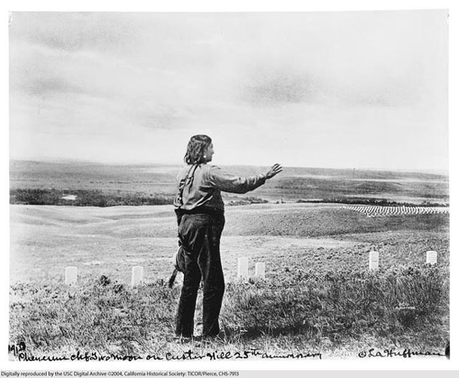
I'm afraid that one of the long standing difficulties with orienting participant accounts has crept in and popped up. The Crow Agency was West in the sense that Indian west is west or otherwise it could have been north but they would have been meaning west because that is where the agency was. Using the Crow Agency to orient location related to Crow Agency produces significanr distotion of the intent. Crow Agency was west. If the river axis compass is used then Crow Agency was still west but South and not the west applied today. It was at Ft. Parker first and at the time of the battle it was near Columbus at Absarokee and in 1878 when Nelson A. Miles conducted the official investigation of the battle, it was still at Stillwater and remained there until 1884. The Crow Agency referred to is not and cannot be, the present day Crow Agency SouthEast of Billings on the Little Bighorn River. So, reconsider please. The direction was not down the valley but across it. It's very important orientation of events tactical. When Two Moon stood here in this image, the Agency was west down the valley but when he fought and for the eight years following, the Agency was west across the valley. In the same direction in which the women, children and older men fled from Reno and Custer's attack. Two Moons obviously knew what he meant but many of us do not or don't want to. Tribal recounting of events was rather parrot like once the first account on eve of battle was given and would be repeated word perfect ad infinitum until ad finitum. This same difficulty applies to the cemetery which for Cheyennes and Sioux was the battleground cemetery where they fough and wehere the soldiers were first buried. With that insight adjusting the Timber and Powell interpretations of events you will understand how the 20 minute halt really occured at Deep Coulee where for instance Two Moons stated that the first soldiers were killed. That would be the Finley fighting. Two Moons then swung along Greasy Grass Ridge to his position at Custer's Hill and we all know what happened there. Maybe we can dig up Darkclouds stuff on this. Anysways, it looks like Company E were cut off from F which got whacked and blown away as the Calhoun Finley fights were steam rollered and Keogh got the surprise of his remaining life. You are of the opinion that Cheyenne herds were east of the river. They were not. However, as the Cheyennes streamed over Realbird ford and onto Greasy Grass Ridge they would have become aware of the cavalry being able to move downriver where their herds emained. The hostiles did not slack or stand around blowing kisses. Custer is after our horses...... Get Custer! |
|
|
|
Post by herosrest on Oct 2, 2017 11:35:31 GMT -6
Shan, Custer wouldn't have been aware of what was going on at Calhoun Hill because he was heavily engaged at that time. He didn't leave L company behind along with C and I. He needed all the combat power he had available to effect a river crossing and make a significant impact on the village. He would have taken all 5 companies to the ford D area, where there are several crossing places. If you look at the river course in 1876, you will see a crossing near where the bridge and interstate are located, and another one is a little more upstream and is at a right angle to the first. This would give Custer the ability to hit any resistance from two different directions, if that resistance was light or composed only of fleeing non-coms. As it was, the resistance was heavy and already on the east side of the river. Hence the crossing plans were thwarted. Now when you plan an assault, you always setup rally points for everyone to meet at in the event things go awry or folks get separated from each other. The high ground of Cemetery Ridge and Battle Ridge Extension are the logical rally points for 5 companies going to 2 different crossing points. When the crossing attempt was foiled, it took some time to get everyone back to the rally points, and get a plan in place for what to do next. This could take from 15 to 30 minutes easily considering the terrain, distance involved, tired horses and men perhaps on foot. It is my belief that E and F, and probably HQ rallied on CR, while C, I, and L rallied on BRE. With the amount of hostile activity, it would be logical on Custer's part to assume he could withdraw back the same way he came, so tactically he would have ordered a covered withdrawal. The lead element to withdraw first would have been L company, followed by C, then I, while E and F provided the cover for the withdrawal. L gets to Calhoun hill, encounters heavy activity from those crossing at ford B, sets up skirmish lines and engages, waiting for the rest of the battalion to show up. C arrives next, sees the open right flank on L company and moves into the coulee to cover that flank, unaware of all the hostiles on greasy grass ridge. All the while C and L are doing this, E, F, and I are also engaged heavily. I company is the next to leave the area but gets trapped in transit by hostiles coming from Deep Ravine through the gap, and by Indians that had been on L companies left flank who continued over to the east side of battle ridge. And also while I is moving out, E and F fold due to pressure, with F moving to LSH and E mostly moving off CR toward Deep Ravine. What was going on was 3 different battles occurring at the same time in different places. There is artifact evidence to support the fact that there was fighting north of LSH, as several rifle cases belonging to rifles from C company have been found north of LSH on BRE, along with a colt SAA revolver. So, the reason Custer didn't rush to Calhoun hill to assist was because things didn't happen in the order your question presupposes. Anyway, that is my opinion. This broadly is Kuhlman's fight with delay on the Custer Ridge spur explained and fleshed out by opposed crossings below. It was my view of things forty years ago until around about twenty or so ago. It truly was unfortunate that Charles was deaf 'cos Custer could have cleared the whole thing up otherwise when he visited on the Battlefield. None of Marquis's informants, actually mentioned or suggested that there was slow fighting on Custer's field. The only period of delay which is broadly corroborated across both sides is that at Deep Coulee. The lower fords concepts come from interpretations by people who were not born when the battle was fought. In the case of JSiT, the participant evidence upon which he relied is completely at odds in the participants accounts. That is, those who fought and left accounts for us, do not tell us what Timber did. You certainly could be right or on to something but all the evidence that exists suggests that nothing other than flight by stampeded horses and perhaps later escape attempts took place on the land. There are significant problems with the Timber and Powell histories. There is a problem with that land being owned by a collector of some stature and influence - Paul Dyck. There is no need to look further than George Bird Grinnell to learn where and which ford was central to Custer's attack. The cavalry approached it, halted and dismounted and waited. This same information was the basis of E.S. Curtis's understanding of events. The ford was Realbird. Custer was there when Reno reached Reno Hill and several hundred hostiles including White Bull then moved from Weir Peak to attack the five companies who pulled back from the river. We know from Two Moons maps where the attacks made by Yellow Nose and Two Moon originated from. We know that White Shield was with Two Moons to see Yellow Nose capture a flag. Rain in the Face got one as well. Kuhlman post dates Bordeaux and Bordeaux developed a very interesting theory from participant record. So, This is the Brule Sioux equivalent of the Cheyenne history given by Timber, with Bordeaux likewise related to tribe and participants. It can be argued that Kuhlman plagiarised Bordeaux. I do not believe for one second that Weir, in advancing towards Custer, brought about the massacre which is the central point of Kuhlman's off by one theory. Hare corroborates this depending upon what time you believe that he arrived with Weir to see what could be seen. This photo of Joe Medicine Crow as a boy hangs in the Hardin, MT public library. Joe is the boy in the center, wearing red. The photo was taken by Thomas Marquis, author of, "Save the Last Bullet For Yourself." The photo was probably taken ca. 1925. 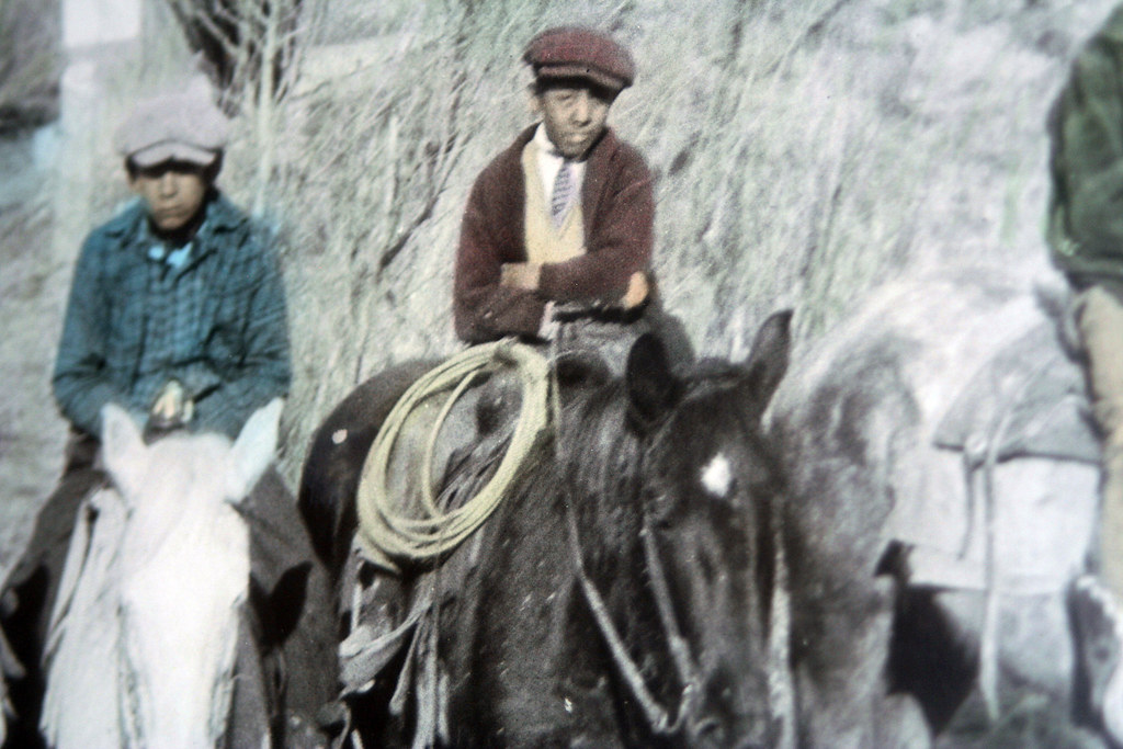 |
|
|
|
Post by noggy on Oct 3, 2017 4:56:18 GMT -6
Shan, Noggy, Two very thought provoking posts. How about their horses were run off and they are pushed to that position from, say, CR while in defensive posture. Regards, Tom Your scenario is a possibility, absolutely. My problem is that there many things that could have happened. The theory I find the least likely is however the popular one about a skirmish line running down there. Btw, a question for those who know how command structure worked in the US cavalry; would a company`s commanding officer lead or be near the skirmish line? Smith lay dead up on LSH, and Sturgis may have been killed much earlier. The whole head-thing indicates he was killed closer to the river, anyway. |
|
|
|
Post by herosrest on Oct 4, 2017 9:25:09 GMT -6
Calhoun and Crittenden were given as killed in their positions behind the skirmish lines. Marker placement does not reflect this - perhaps Sweet wasn't up on that with theory prevalent in 1890. The strands of a movement beyond LSH onto National Cemetery terrain, Custer Ridge's northwestern spur and ravines west towards the bluffs and river are wisps of imagination with nothing at all to support them besides effort by Fosx for example which give that because there is no archaeology, the troops were there. Finding the correct words for this type of endeavour is difficult. Beyond me for now. However, here is demolition of one of the strands which was prepared earlier - Another of the end game problems stems from composition of the battalions which formed the regiments right wing. Yates battalion was composed of Companies E and F and L. Company B was a component of Keogh's battalion. In olden days this would trigger quite derisory assault from the 'board' sic but fortunately that doesn't change the reality and things ain't what they used to be. There was no reason for Custer to alter what was before although this did take place with Benteen's battalion because, I believe and if memory serves, he requested a strengthened company. Onward... yooooo! |
|
|
|
Post by AZ Ranger on Oct 5, 2017 8:09:00 GMT -6
I think for those that actually go to battlefield we have to constrain ourselves when reading some opinions. The interstate runs between the junction of 212 and Crow Agency. The old roads went the same direction. You also left out the buildings which to my knowledge are only on CR. Do you have sources for other locations?
The turn described is perfect for BRE. Walk out of the back from the Indians monument and you start down BRE. At that point your walking directly toward Crow Agency. You can see the fairgrounds in the direction of Crow Agency. Travel a little further and you can make a turn toward the LBH river. That point along BRE is what is being described or it is consistent with what is being described. I see no other place that has all of the characteristics starting with the buildings.
The real issue is that you have ignored the hundreds and hundreds of artifacts defining Indian and Trooper locations. Do you believe that Douglas Scott and Michael are not providing factual locations of the artifacts?
I think they are two of the finest and most honest persons I have met.
Do you think that the Cheyennes we see just across the river near Ford D are confused?
I don't they are not there for public consumption. It is not an event it is their respect for their history.
Do you think that Cheyennes were restricted to only one crossing place?
I think they could go wherever they wanted .There was nothing done by the 7th Cavalry to close interior lines of movement. That could have been done in the valley but never from the bluffs. I think some Cheyennes may have fought Reno, some may have crossed at Ford B, some crossed in the Ford D area, and others crossed wherever they decided to cross. There was nothing to stop them.
So how many Indians sites that indicate firing positions are you aware of north of LSH? The ones near highway 212, BRE, or CR below the military crest toward the Crow Agency direction?
Regards
Benteeneast
|
|
|
|
Post by herosrest on Oct 5, 2017 15:37:33 GMT -6
In a nutshell, absolutely none of  these. Kuhlman seems to have missed finding them and pretty much anyone else. Of course there may be an extremely obscure research paper somewhere which makes reference to their provenience. I understand that the given items date to 1994 when Scott undertook work on this terrain. 800-1000 army cartridges attributable to the battle would obviously have revolutionised thinking 23 years ago. This is beginning to look like another six stone markers near the old stone house matter which it was shown were in fact there but entirely unrelated to the battle. They are still there now and just as unrelated. As I have shown previously, 7th Cavalry did ride up to the cemetery ridge or bluff and there is photography and video/film of it taking place - in 1926 with battle veterans present re-enacting the battle amongst the 50,000 who attended for each of 3 days. Army cartridges have been found in a location consistent with that where the scout Curley viewed the battleground. F.E. Server traversed that terrain scouting ahead of Terry's advance and did not discover cartridge evidence such as that existing where troops actually fought. He was aware of cartridge finds made during Terry's post battle investigation. He did not locate the newspaper reporter in covering that terrain. It may be very worthwhile to go back and re-assess interpretation of Gibbon's route to the discovery of Kellogg's remains. That would be very wise. I believe that a research paper on this has been done and a review is most desirably desirable. Catholic Quaterly, I think it was that had the two articles but almost certainly someone haas published them since. His marker was donated by the paper which laid claim to him, the Herald, I think and it would be interesting to learn how and when it was shipped and placed on the cemetery grounds of the monument. If we, take up the maps,  Here we can see the type of stuff which Timber developed into the account given in 1956. Would you not expect Vaughn to have been all over that terrain immediately l  king for unexploded mines? A revelation such as that, to experts experienced in searching out the military evidence and nothing of significance discovered. Nothing of note from Luce with regards that terrainn and he, again, was most certainly aware of the significance of battle related relics. Before him, both Godfrey and Walter Camp fully appreciated the importance of such evidence and Camp was around before the discoveries by Blummer and Godfrey was afterwards with his passing away in 1932. Timbers map shows an approach by cavalry using an unknown route onto Calhoun's demise then following the old blacktop route and past the north west national cemetery corner to descend towards the old road bridge before swinginging around and back up across the south west corner of the national cemetery heading east onto Finley Hill where the route reverses towards the monument cemetery and Custer hill and then reverses again towards the Calhoun fight. This is entirely at odds with first hand accounts from Sioux tribal leaders which were given to Server and McLouglin both of whom had excellent Sioux language skills. Timber contradicts the accounts of his own informants. Had there been six battle related markers near the old stone house then at least it could be argued that Custer's vidette died there but it would not explain the route from that area back to Finley Hill, up to Custer Hill and then on to Calhoun Hill. This doesn't mean that no sense can be made of Timber's analysis of his data. He was at the 50th anniversary and therefore saw 7th Cavalry re-enact the battle by riding up from the river over parts of the route he indicates on the map as being used in 1876. 1926 was a re-enactment and perhaps the relevance of this was lost to him. To this day no-one understands the fight so how was it re-enacted other than symbolicly? Marquis photographed Timber, his wife and son in 1926 and yet Marquis's ideas of the battle are considerably removed from Timber's and rooted in realities at least of Two Kettles besides drums along the Little Horn. |
|
|
|
Post by herosrest on Oct 6, 2017 6:12:21 GMT -6
A number of causes are attributable to continuing dissastisfactions with presentations of Custer's fight at Little Bighorn and one of these is the movement undertaken by companies once they advanced to attack in flank and or rear. It is remarkable that this would occur without Maj. Reno being so advised but posterity's hindsight has it that way. Examination of the various evolved theories of movement leave four as extant.
Movement down Medicine (Reno C.) Tail Coulee to the river.
Movement from Blummer's Nye Cartwright Ridge to the river.
Movement from Calhoun Hill towards the river.
Movement from Custer's Hill towards the river.
All of these movements were possible during the given time-scale between Reno separating from Custer and Lt. Hare observing Custer Hill when he advanced to join Weir's position in advance of Reno on the bluffs.
Two interpretations by white people experienced with the Sioux Language, indicate that Custer's movement from Last Stand Hill was towards the mouth of Deep Ravine and this was intercepted and smashed backwards up the hill and overwhelmed. The coherent evidence which we have indicates that Keogh's company were overwhelmed before the wounded and survivors on Custer's Hill succumbed. The flight of survivors from Last Stand Hill back into Deep Ravine should be considered with considerable caution since it may well be that the flight to escape actually traversed the ravines leading down to the river at the road and railway bridges over the Little Bighorn.
GEN. SHERIDAN ON THE CUSTER DISASTER.
Custer reached a point about three and a half or four miles down the river, but instead of finding, a village of 75 or 100 lodges, he found one of perhaps from 1500 to 2000, and swarming with warriors, who brought him to a halt. This, I think, was the first intimation the Indians had of Custer's approach to cut them off, for they at once left Reno and concentrated to meet the new danger. The point where Custer reached the river, on the opposite side of which was the village, was broken into choppy ravines, and the Indians, crossing from Reno, got between the two commands, and as Custer could not return, he fell back over the broken ground with his tired men and tired horses (they had ridden about 70 miles with but few halts) and became, I am afraid an easy prey to the enemy. Their wild, savage yells, overwhelming numbers, and frightening war paraphernalia, made it as much as each trooper could do to take care of his horse, thus endangering his own safety and efficiency. If Custer could have reached any position susceptible of defence, he could have defended himself; but none offered itself in the choppy and broken ravines over which he had to pass, and he and his command were lost without leaving any one to tell the tale.
As soon as Custer and his gallant officers and men were exterminated and the scenes of mutilation by the squaws commenced, the warriors returned to renew the attack upon Reno; but he had been joined by Captain Benteen and the four companies of the regiment that were behind when the original attack took place, and the best use had been made of the respite given by the attack on Custer, to entrench their position.
Had the 7th Cavalry been kept together, it is my belief it would have been able to handle the Indians on the Little Big Horn, and under any circumstances it could have at least defended itself; but separated as it was into three distinct detachments, the Indians had largely the advantage in addition to their overwhelming numbers. If Custer had not come upon the village so suddenly, the warriors would have gone to meet him, in order to give time to the women and children to get out of the way, as they did with Crook only a few days before, and there would have been, as with Crook, what might be designated a rearguard fight, a fight to get their valuables out of the way, or in other words, to cover the escape of their women, children and lodges.
CUSTER'S LAST BATTLE. THEORIES OF THE ENGAGEMENT.
GENERAL CUSTER'S trail, from the place where he left Reno's and turned northward, passed along and in the rear of the crest of hills on the east bank of the stream for nearly three miles, and then led, through an opening in the bluff, down to the river. Here Custer had evidently attempted to cross over to attack the village. The trail then turned back on itself, as if Custer had been repulsed and obliged to retreat, and branched to the northward, as if he had been prevented from returning southerly by the way he came, or had determined to retreat in the direction from which Terry's troops were advancing.
Several theories as to the subsequent movements of the troops have been entertained by persons who visited the grounds. One is, that the soldiers in retreating took advantage of two ravines; that two companies under Capt. T. W. Custer and Lieut. A. E. Smith, were led by Gen. Custer up the ravine nearest the river, while the upper ravine furnished a line of retreat for the three companies of Capt. G. W. Yates, Capt. M. W. Keogh, and Lieut. James Calhoun.
At the head of this upper ravine, a mile from the river, a stand had been made by Calhoun's company; the skirmish lines were marked by rows of the slain with heaps of empty cartridge shells before them, and Lieuts. Calhoun and Crittenden lay dead just behind the files. Further on, Capt. Keogh had fallen surrounded by his men; and still further on, upon a hill, Capt. Yates' company took its final stand. Here, according to this theory, Yates was joined by what remained of the other two companies, who had been furiously assailed in the lower ravine; and here Gen. Custer and the last survivors of the five companies met their death, fighting bravely to the end.
Another theory of the engagement is, that Custer attempted to retreat up the lower ravine in columns of companies; that the companies of Custer and Smith being first in the advance and last in the retreat, fell first in the slaughter which followed the retrograde; movement; that Yates' company took the position on the hill, and perished there with Custer and other officers; and that the two other companies, Keogh's and Calhoun's, perished while fighting their way back towards Reno-a few reaching the place where Custer first struck the high banks of the river.
Still another theory is, that the main line of retreat was by the upper ravine; that Calhoun's company was thrown across to check the Indians, and was the first annihilated. That the two companies of Capt. Custer and Lieut. Smith retreated from the place where Gen. Custer was killed into the lower ravine, and were the last survivors of the conflict.
Frances Fuller Victor, 1877.
|
|
|
|
Post by AZ Ranger on Oct 6, 2017 6:55:22 GMT -6
HR
Your understanding is not correct and if you read Scott's book you would understand why it list numerous sources. Weibert also has findings north of LSH and I have talked with a person who was with him for the findings. The picture you posted seems to be one that I took and it is Donahue's.
Until you read Scott's publications and Donahue's you will never be able to form an opinion based on the factual information that is now available. What makes you think that Scott had anything to do with construction of the older entrance road. What date to you for the construction of that road and the findings of those constructing a road?
As far as Kuhlman which road construction was he involved in where he could see the results of moving material and disturbing the land?
What equipment was available to Kuhlman to make findings in undisturbed conditions?
Even Scott needed the fire in order to use his more sophisticated equipment.
Opinions are always subject to change with the findings of new facts. You have no ability to determine if Kuhlman would have changed his opinion given all the findings north of LSH. Facts change opinions but opinions should not change facts. Kuhlman only rendered an opinion it is and was not fact. His opinion was maybe the best he could come up with for what he had to work with at the time. I absolutely reject the idea that Kuhlman had modern electronic devices and that went around disturbing the ground looking for artifacts unless you can provide proof that he did.
Again anyone that has been to the battlefield knows that the picture you show is not CR the cavalry is south of CR in that photo yet maintain it taken on CR. The photo of the kneeling infantry is CR and the Indian participant place them there and they were facing BRE.
Regards
AZ Ranger
|
|


 I try!