|
|
Post by Jas. Watson on Feb 18, 2008 11:12:59 GMT -6
Another forum (ex-)member and I were looking at an archaeological map the other day and we notice the lineup of soldier casings in Luce ridge--it is not straight but is definitely angular--and none of it particularly facing ford B as was the later Nye-Cartwright line. The question that arose with both of us is just who were they shooting at? And which direction were they laying down that considerable base of fire. Unfortunately the impact area has not been found yet.
A thought here: Perhaps GAC in his original plan to go down Medicine Tail Coulee and cross ford B ran into a whole bunch of hostiles and could not get down MTC, so rather had to go up on the ridge. The fire line looks like it could be supressive fire against a bunch coming up MTC.
Then in order to try it again he had some troops lay a base of fire toward ford B (Nye - Cartwright) but couldn't get down there with any force either--there is very little soldier evidence found anywhere in the ford B area.
In otherwords, MTC and Luce Ridge was Custer's 'skirmish line' and 'timber fight'. And he ran into the same situation that Reno did...and reacted much the same way.
Jas~
|
|
|
|
Post by elisabeth on Feb 18, 2008 12:19:11 GMT -6
From that map (if it's the Bonafede one) it certainly looks as if the fire was directed at something closer than Ford B. Indians coming up MTC, indeed -- and also some possibly coming from the bluffs? The Luce fire especially looks angled in that direction. If so, it could explain the decision to press on rather than fall back on his support when the scale of the opposition became manifest.
What do you make of the way the casings on Luce/N-C look like a lengthy soldier occupation there, in startling contrast to Battle Ridge? Easily explained by Indians policing up casings on Battle Ridge, if that was perceived as the site of the "real" fighting ... But it made me wonder if "the ridge" where the Indians recounted a long period of slow firing mightn't have been Luce/N-C rather than Battle Ridge. In which case all the received wisdom about L stationed here, C there, I in reserve, etc., would need re-examining, and it would start to look rather more like a wholesale retreat northwards with the various companies fighting rearguard actions in turn.
And yes, I've already been ever-so-politely (I think) laughed at* by very possibly the same ex-forum member for the notion, so it may of course be nonsense! Even so -- if we were looking at that map without any Indian accounts to help us, and without any pre-conceived ideas, I can't help thinking that's pretty much how we might read the map evidence ...
*I've been told, incidentally not by the person in question, that I may have given the wrong impression with this flippant wording. I must apologise and admit I was exaggerating for effect; I didn't mean to impugn the ex-forum-member's open-mindedness at all. In fact he merely reserved judgement. (Me and my big mouth ... Sorry, all.) Was only wishing to say I might have been an idiot. As may well be the case.
|
|
|
|
Post by Jas. Watson on Feb 18, 2008 15:12:27 GMT -6
Elizabeth,
What you say makes sense to me. One reason for the comparative lack of casings on Custer field might of course be the years of folks visiting and picking things up...however that doesn't explain the comparative lack of Indian shells in the outlying areas--as compared to the Reno hilltop fight. It looks as though Reno took quite a bit more fire than Custer did even if you do account for the years of pickups (and let us not forget that there was plenty of other artifacts found during archaeology so there wouldn't have been that much picked up over the years).
Of course the Reno fight took place over a much longer period of time but still the evidence sure shows a lot more fire delivered to Reno than Custer even so. Reno hunkered down and dug in and was able to survive, had he not I'm sure the outcome would have been the same as for GAC.
No, I like your idea.
Jas~
|
|
|
|
Post by ignimbrite on Feb 18, 2008 15:15:59 GMT -6
[ The question that arose with both of us is just who were they shooting at? ] That's the first question my son asked as we looked at the Bonafede map earlier this year. I didn't have a good answer. My January trip to the battlefield was mainly to locate Luce and the Nye-Cartwright ridges. Even when I found the ridges who the shooting was at wasn't apparent to me.  Ruth |
|
|
|
Post by shan on Feb 18, 2008 15:34:27 GMT -6
Elizabeth,
I've been looking at that map and puzzling over those clusters of shells on Luce, and indeed those on Nye for the last couple weeks,{ finally got to dealing with this part of the battle in the never ending book,] and like you and Jas, I've come to the conclusion that the troopers up there were firing at something other than targets at the ford, probably at something or someone in and around Medicine Tail coulee area.
In turn this has made me have to stop and re-think the supposed skirmishing with Wolf Tooth and Big Foots Cheyennes that supposedly happened in this area, a notion I've never felt comfortable with. No matter how many times I've read the descriptions of this event in the Peter Powell book I still find them rather baffling and contradictory, and if I was to believe something of the sort happened at all, then at a squeeze I thought it may have been these Cheyenne firing at Custers disappearing force just beyond LSH.
But, there's that big BUT that lives in the head of all those with an interest in this battle, its just possible that they were attempting to come down behind the companies heading for MTF, and that those up on Luce were trying to deter them them and drive them off.
But as I say, I've had to reconsider the possibility that it was indeed those Indians, especially given that there does seem to have been an awful lot of firing going on on the part of the army as they crossed those ridges heading North.
Given that I have never been emoured of the idea that there was long slow period of firing once the two sides got to the Calhoun area, I think your right, I believe that the period the Indians describe in that way was possibly this exchange going on Luce and Nye, the pause before the storm so to speak.
Shan
|
|
|
|
Post by Montana Bab on Feb 18, 2008 22:33:12 GMT -6
From that map (if it's the Bonafede one) it certainly looks as if the fire was directed at something closer than Ford B. Indians coming up MTC, indeed -- and also some possibly coming from the bluffs? The Luce fire especially looks angled in that direction. If so, it could explain the decision to press on rather than fall back on his support when the scale of the opposition became manifest. What do you make of the way the casings on Luce/N-C look like a lengthy soldier occupation there, in startling contrast to Battle Ridge? Easily explained by Indians policing up casings on Battle Ridge, if that was perceived as the site of the "real" fighting ... But it made me wonder if "the ridge" where the Indians recounted a long period of slow firing mightn't have been Luce/N-C rather than Battle Ridge. In which case all the received wisdom about L stationed here, C there, I in reserve, etc., would need re-examining, and it would start to look rather more like a wholesale retreat northwards with the various companies fighting rearguard actions in turn. ... Elisabeth, This is really an interesting theory on this thread, and one that makes sense to me. Every time I think I have a slight handle on this battle.......... Where could I get a copy of that map of which you speak? Thanks, Montana |
|
|
|
Post by elisabeth on Feb 19, 2008 3:21:26 GMT -6
Montana, Upton's have it, for $10: pub.sandiego.com/shop/store2.idc?s=8&i=-12010&c=16and the Western National Parks Association also have it (for $7.99). No sign of it on Amazon, which is a bit surprising. I know, it's maddening, isn't it. Same here; every time I think I have a slight handle on this battle, something else turns up and I have to rethink ... |
|
|
|
Post by Montana Bab on Feb 19, 2008 14:20:06 GMT -6
Bless you, Elisabeth !
I'll order the map straight away!
Thank you, Montana
|
|
|
|
Post by clw on Feb 21, 2008 17:24:08 GMT -6
Shan wrote "that its just possible that they were attempting to come down behind the companies heading for MTF, and that those up on Luce were trying to deter them them and drive them off."
I usually avoid mentioning oral history due to credibility issues, but, for what it's worth, I have heard some pretty specific Lakota oral history that strongly backs that up.
|
|
|
|
Post by fred on Feb 21, 2008 19:17:46 GMT -6
When I saw "Jas. Watson" post this thread, I immediately thought it would be a great culmination of a thread designed to try and figure out Custer's route to Luce Ridge. Unfortunately, like so many others, the "Custer Route" thread, try as I might, has gotten off on the usual tangent. I figured I would save my comments for "Watson's" thread until the "Route" was exhausted. I guess I should have known better.
So, I will enter this discussion, slowly, with the following:
Feather Earring, 1919: “The Indians had crossed the Greasy Grass Creek above where Custer tried to cross, in great numbers, and cut him off from Reno. They got around behind (east) him.” [Graham, The Custer Myth, p. 97]
If Custer “tried” to cross at Ford B and the Indians got between him and Reno, that obviously means the Indians crossed somewhere in between. If that is possible, then it could explain the firing positions seen on the Bonafede map of Luce Ridge. There would probably have been only a few Indians-- remember the business with Gall?-- and that might explain the shallowness of that "W"-shaped artifact field on Luce Ridge, especially when you compare it to the larger field on Nye-Cartwright.
And "Montana"-- by all means, get the map. It's great. The LBH Battlefield bookstore will mail it to you. I ordered 3 or 4 of them because after I handle them so much they begin to tear. Its like a large Google-Earth with all sorts of color overlays. $7.99.
Best wishes,
Fred.
|
|
|
|
Post by elisabeth on Feb 22, 2008 7:15:20 GMT -6
At the risk of diverting this thread, too, onto the usual tangent: looking at the map, there's no obvious crossing point "above" Ford B, other than a few coulees just as inhospitable as the one Reno used on his retreat. Of course the Indians were better at coping with the terrain, plus much depends on Feather Earring's translator (a) getting it right, and (b) understanding the direction of flow of the river. But with those caveats -- what if Custer's serious attempt at crossing was in fact further downstream, e.g. at Deep Ravine? It would fit with Big Beaver's map, and with Peter Thompson's story (OK, I know, not the most copper-bottomed witness) of seeing fighting downstream of MTF; and I seem to remember a few hints in other Indian accounts as well ... In which case, the rush of Indians across the river could be at MTF and up MTC. A much easier place to cross "in great numbers", from the look of it. The ragged "W" at Luce could then be the rearguard company suddenly spotting the threat and dealing with it, with the (say) two companies ahead of them in line of march halting at N-C to back them up when they grasp the emergency.
Just a thought ...
|
|
|
|
Post by Jas. Watson on Feb 22, 2008 8:38:10 GMT -6
I personally like Elisabeth's conclusion that the Hostiles were coming up MTC. The ford is easy, the route is obvious if you know that some soldiers are coming that way--it is quicker to get into the fray.
The question I have is how far did the troops actually get in their mission of hitting ford B--or were they even trying? I think GAC's original plan (such as it was at this point) most likely included a foray to for B because, again as it is the most likely place and he too wanted to get into the fray soonest. And seems the most logical.
But I think it was this Indian advance that changed all the plans and let to the firing on N-C ridge ultimately. Whether there was ever an advance to ford B is debatable because as Fred says why attack with less than half your men? But if this is so, than what were troops doing down there? Because apparently there is enough witness accounts that seems to say that at least some were down there.
Questions, questions....
Jas~
|
|
|
|
Post by conz on Feb 22, 2008 13:59:05 GMT -6
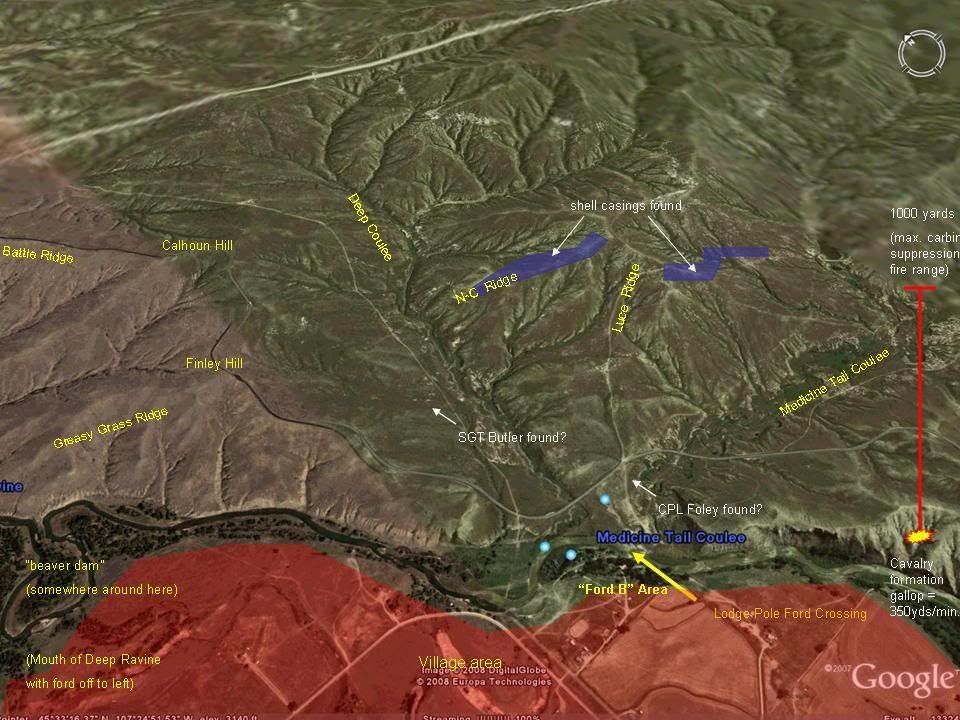 The "T" at the top of the red "weapons range" line is about the size of a cavalry company skirmish line on this view. Clair |
|
|
|
Post by Jas. Watson on Feb 22, 2008 14:40:21 GMT -6
Excellent map work Conz! One can see by your range arrow that even pushing 1,000 yards (which is optimistic). There wouldn't be really effective fire put on the ford itself from either position...just out of real effective range. Hmmm...food for thought certainly.
As an aside; That top of the T showing the length of a company in skimish order would be interesting to superimpose in certain areas of the Reno valley fight. It might show just how little the three company skirmish line would cover of the valley and how easily they were flanked--and also the forlorn hope they had of actually effectively defending the timber with those few men.
Great work, love it!
Jas~
|
|
|
|
Post by fred on Feb 22, 2008 17:49:24 GMT -6
Clair--
Your "Butler found" spot is wrong. I think they place him somewhere down that path extending from Luce Ridge to the "intersection." Maybe mid-way down that path.
A beautiful job!
Best wishes,
Fred.
|
|


 "If there are no dogs in Heaven, then when I die I want to go where they
